If you are following us on a map, you can see that it was another short trip for us. We gassed our vehicles in Ft. Nelson before heading to a parking area about twenty miles west of town. We parked the RVs in the rest area and we took off on British Columbia Highway 77 for Northwest Territories. This parking spot was the closest we would get to Northwest Territories--about 100 miles north.
On our way north we crossed a one lane bridge formerly known as Bailey Bridge, now called Acrow Bridge. It is the longest Acrow bridge in the world. Traffic traveling south has the right of way on the bridge.
This is a view of the bridge from the northwest.
The road was paved and relatively smooth all the way to the British Columbia/Northwest Territories boundary.
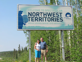
It was nice to get out and stretch our legs in this northern province. And, yes, those are bullet holes in the sign. It doesn't matter where we travel in the USA or Canada, we always see signs with bullet holes.
Then it was time to get in the car and return to our rigs. The road heading north beyond the boundary was gravel! There hadn't been rain in many days and the dust kicked up by the vehicles that passed us was horrendous. We would have enough dust once we got to Top of the World Highway, no need to travel in the dust now!
On our way back to our rigs, we passed several black bears munching on flowers on the side of the highway.


No comments:
Post a Comment