Friday, November 30, 2012

West to the Salton Sea

Bob and I  enjoyed the Yuma area, even if we did have to buy a new tire after we got a slow leak in the sidewall of the rear passenger tire (while we were geocaching, of course). We even tried a local specialty--a date shake at Martha's Gardens. Yes, it was good. We have heard that a place in Indio, California, has the best date shakes. We'll let you know.

We left Mittry Lake after our 10 day limit. On our way to I-8 we stopped at a local RV park to dump our grey and black tanks. Friends told us not to get water at the RV park as it wasn't very good. They said the rest area on I-8 before El Centro, California had great water and a good view of Imperial Dunes. Of course, we topped off the gas tanks in the RV and the car; we also filled our propane tank even though it wasn't down very much before leaving the Yuma area.

As we drove west on I-8, we began to see road construction. Oh, no! The rest area was closed! Now where would we find fresh water to fill our tank? Well, after looking at my map on the laptop, I suggested we go to the military base just west of El Centro. If nothing else, maybe we could fill our fresh water tank. After little discussion, we headed for El Centro NAF (naval auxiliary field), winter home of the Blue Angels.

We were able to get a campsite for the night and the Auto/Hobby Shop had a free car wash so the CRV is now clean (for a day anyway). We took the opportunity of having full hook-ups to have long, luxurious showers, to use the microwave, and to enjoy cable television! We hadn't had hook-ups for 39 days--since the RV park near Zion in Utah! We plan to continue not having hook-ups the remainder of our time in California.

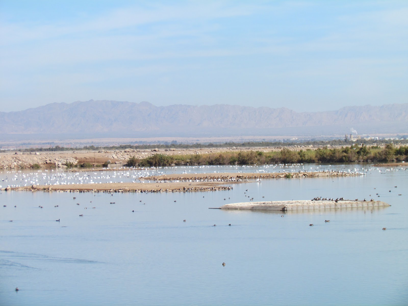
The next morning we stowed our things and headed for the Salton Sea. It is the largest lake in California. Our first stop was Sonny Bono National Wildlife Refuge at the southern end of the lake. After looking around the visitor center we walked Rock Hill Trail to see Salton Sea. Near the end of the trail we saw an area with man-made islands. Salton Sea is saltier than the Pacific Ocean, but this pond has fresh water pumped in for nesting birds. The pond also has an electric fence around it to keep out predators.
 In an effort to keep migrating birds out of farmers' fields, the refuge plants fields near the Salton Sea with crops especially for the birds. This seems to work because these were the only fields where we saw birds.
Rock Hill Trail is named for this hill leftover from volcanoes long ago. In fact, the trail had a lot of obsidian in it as we walked the refuge. The San Andreas Fault lies under the Salton Sea.
There was a nice view of Salton Sea from Rock Hill at the end of the trail.
From the refuge, we traveled north to Salton Sea State Recreation Area. We found a campsite at Rock Creek Beach. There were only 2 other campers at the beach.
One thing you notice when you first arrive at Salton Sea is the smell. The water is too salty for most fish.  Tilapia were brought in to stock the lake and they have thrived. In fact, they are the only fish living in the sea. The beach is covered with fish carcasses.
Birds fly along the shore and swim near the campground. Thirty percent of American white pelicans live here.
This white pelican was enjoying the end of the day floating near our campsite as we enjoyed the sunset.
Friday morning we decided to geocache--are you surprised? Our goal is to have 4000 by the time we get home. One geocache was supposed to be located at this deserted homestead. The water tower is from a WWII airplane. We searched and searched, but could not find the cache.
Of course, when you are near Niland, California, you have to visit Slab City. In 1942 it began as a Marine Corps training camp. By the early 1960s, all the buildings had been sold and moved so that only the slabs were left. That is when an eclectic group began moving into the area. One resident, Leonard Knight, began building Salvation Mountain at the entrance to Slab City.
 Leonard Knight worked on this mountain for over 20 years before his recent death . Volunteers continue his work today.
 After passing Salvation Mountain, you can see all sorts of camping rigs. This was one that caught our attention.The area is definitely interesting.
Tomorrow we will move on to Joshua Tree National Park.

For those interested in our budget, even after buying a new tire ($200), eating out, and sightseeing, we are averaging $62.59 a day.

Wednesday, November 28, 2012

Mittry Lake and Thanksgiving

 Most of you know we are members of an Escapee birds-of-a-feather group called the Boomers. Every year a group of Boomers meets at Mittry Lake for Thanksgiving. Another group meets there at Christmas and New Years. We decided to spend Thanksgiving with the Boomers at Mittry Lake near Yuma, Arizona. Our route from Lake Havasu took us south on US95 through Quartzsite where we will be in January with many, many other RVers. In fact as we drove through, some people are already there for the winter.

It only took about 2 hours for us to get to Mittry Lake. Once there, we had to find where the Boomers were parked. We were told that we would see them on a hill after a big turn in the road. Well, we could see them, but figuring out which dirt road to take to get up the hill was another matter. Bob found a place to park where we could unhook the car and drive the roads to find the correct one to take the RV.
 There were already four other rigs parked on the hill. We found a spot and set up before joining the others for Happy Hour (every afternoon Boomers get together with their beverage of choice and snacks to share along with camping stories).
 Tuesday Bob and I explored the area north and east of Mittry Lake by geocaching. Yuma Army Proving Grounds was at the north end of Mittry Lake. Bob was excited to see vehicles he used displayed near the entrance.
 Wednesday is Boomer Movie day in Yuma. Boomers wintering in Yuma and those at Mittry Lake meet at the local theater to see a movie. We saw the movie Lincoln, but we wished the movie had been Skyfall. After the movie we ate at 5 Guys to celebrate one of the Boomers' birthday.

Thanksgiving Day there was a good sized group for the potluck. Everyone brought something to share. A good time was had by all. This is a portion of our group.
 Friday we went with our friends Connie and Larry to Los Algodones, Mexico. I have never seen so many dentist offices or pharmacies! So many American snowbirds go to Los Algodones for meds and dental work that the town has a celebration welcoming them back to the area every January!

Speaking of snowbirds, Florida has nothing on Yuma. Yuma is the snowbird capital. It is also the leafy green capital of the U. S, Of all the green leafy vegetables eaten on the U.S., 90% come from the Yuma area. I was amazed at how they grow lettuce. If you buy the bag of mixed lettuce in the grocery store you can count on it being grown side by side in the field. Workers cut it and box it for processing all in one fell swoop.
     
Another day we toured the Yuma Territorial Prison Historical Site. 
This is how mug shots were taken at the prison.


Each cell held 6 prisoners. They switched from wooden bunks to iron bunks after bed bugs and other critters became a problem.
 
 It was interesting to visit the museum and read about why the prisoners were incarcerated. Most of the women were jailed for adultery. One woman stabbed her unfaithful lover, then cut his heart out and threw it in his face--she got 6 years for manslaughter. One man was a polygamist and he got two years. Only two prisoners escaped and were never caught or seen again.
 
 One couple who joined us for Thanksgiving at Mittry Lake were not Boomers. Anton and Annuka are from the Netherlands. Anton designed and built their rig. Annuka helped with the interior. They have been all over the world on their many trips. Their first trip 6 years ago was through Europe and the Middle East to India, Nepal, and Tibet.
 Bob and I did some hiking around the area. This is a picture from the mountain near the campground. Ours is the one nearest the VW camper.

 Of course it was time for another full moon. It was above the mountain before dark.
 Bob and I also visited the Quartermaster Depot in Yuma. Living quarters, offices and vehicles were on display.
 This 1913 Ford is on a section of wooden planks that were used to make a road across the sand dunes. If you went faster than 10 mph, the car would bounce off the road!
 This Ford was modified into a truck to transport farm goods in California.
 We enjoyed our time at Mittry Lake, but our tanks are getting full, time to find the dump and fresh water so we can move on down the road.

Tuesday, November 27, 2012

Heading South--Lake Havasu City, Arizona


As we left Katherine Landing heading for Lake Havasu we stopped to fill the RV with gas at Fort Mojave. The gas was $3.55 a gallon. We would be traveling a short distance through California and we knew we didn't want to buy gas there! As we crossed the border into California, the price of gas jumped to $5.19 a gallon, glad we didn't need any. Also, the route we traveled to Needles allowed us to bypass the agricultural station. I always forget that California doesn't want produce from other states in its borders and I had just purchased salad veggies.

We traveled east on I-40 to Lake Havasu exit and then headed south once again on US95. About 9 miles north of Lake Havasu City we saw RVs camped on a plateau. We thought it was Craggy Wash as the book we have said you would be able to see the RVs from the highway. We missed the entrance so we continued on to town, stopped at Wal-Mart just north of town, did some shopping and headed back to the area where we saw the campers. We pulled in and found a fairly level spot for us to spend the next 4 nights.

The next day we set out to find some geocaches and to check out the Visitor Information Center which just happened to be located at London Bridge. After gathering information about the area, we walked around the 'English Village' beneath the bridge. Most of the shops were closed as it was off-season.

When London Bridge was first moved to Lake Havasu City, there was no water running under the bridge. The town decided it wanted water under the bridge so Bridgewater Bay was dredged so water from Lake Havasu would flow under the bridge. Bob and I walked the 3.6 mile trail around the island that was formed when the bay was dredged.

There are miniature lighthouses all over the lake area. We found a geocache near this lighthouse.

We did a lot of geocaching while in the Lake Havasu area. If you've been watching our totals at the top right of this page, you know we went over 3000!

SARA Park, located south of Lake Havasu City has several hiking trails that take you from the desert to the lake. We chose to hike Crack in the Mountain Trail. It ties Dark Angel at Arches as most difficult! We also found several geocaches hidden along the trail. The trail follows a wash between two mountains. As you get to the 1 mile marker, the wash narrows between two mountains, until you find yourself in a very narrow area with several drops. The highest drop was 7 feet, but it was down slick rock and a knotted rope had been added to help hikers down the drop. Sorry, there is no picture because Bob had the camera going down and once at the bottom I know he was thinking, "How is Joyce going to get down this?" instead of taking photos. Well, I sat on my bottom, held the rope, and slid!

Once we got to the lake, it was a nice surprise. I spotted a picnic area with a vault toilet across the way.There wasn't a direct path to the area, but we finally found the trail, that was also a difficult trail as we had to climb up and around on a narrow path with drop-offs before descending to the lake and picnic area. The picnic area is in the upper right quadrant if you look closely. The trail comes down the mountain on the right.

We moved from our boondocking site (which turned out not to be Craggy Wash--we found that closer to town down a 1 mile dirt road and you couldn't see the RVs from the road) to Lake Havasu State Park on Saturday morning. It was time to dump tanks and fill with fresh water.

After our move we decided to drive to Nellie E's, the desert bar just north of Parker. It is built at the site of an old copper mine. This is a facade that the owner built near the bar.
 The only electricity is from solar panels. The bar is only open on Saturdays and Sundays, during fall, winter, and spring.
 There was a live band and the place was hopping. Did I mention that it is 8 miles off highway? It was worth the dusty drive! Nellie E's is an interesting place to visit.
 We enjoyed our time at Havasu, but were looking forward to visiting with friends at Mittry Lake for Thanksgiving. Time to move on down the road!

Sunday, November 18, 2012

Katherine Landing, Oatman, and Kingman, Arizona

Katherine Landing was our next stop in Lake Mead National Recreation Area. It is located in Arizona just north of Bullhead City, AZ, and Laughlin, Nevada. This was another great campground in the recreation area. Only problem with this one was the Internet ran very slow so I couldn't update the blog as I had planned.
This was our base of operations for touring the area north and south of Bullhead City. Of course we geocached every where we traveled. We found quite a few caches as we drove to the quaint mining town of Oatman on Historic Route 66.There was a cache located at this overlook, only it wasn't at the top of the overlook, it was on the side!
 Just before we reached Oatman, we found this Christmas display with a cache located near by.
 Then it was time to cache in Oatman. One cache was located inside a store, in a container on the counter.
 As you can see, wild burros have the run of the town. They stop traffic on main street.
 Another traffic stopper is the gunfight that is held at noon everyday. The proceeds collected after the show go to Shriner's Hospital for Children.
 The local hotel is being renovated, but its claim to fame is that it was the place where Clark Gable and Carole Lombard spent the first night of their honeymoon. We enjoyed our visit to Oatman and then we continued driving north on Historic Route 66, collecting caches all the way to Kingman, Arizona. We climbed this set of steps looking for cache, but we couldn't find it.
Here is a view of Route 66 as it winds it way from Oatman to Kingman.
This side trip took most of the day so we decided to tour Kingman another day.

We spent some time in the casinos at Laughlin. One day I won 900 nickels on a slot machine! We left ahead that day.

On Saturday we drove to Kingman to see Kingman Army Airfield where B17 gunners were trained in WWII.
Located near the air museum was the Desert Diamond Distillery. Bob and I stopped in to take their tour on the recommendation of the tour guide at Kingman Army Airfield Museum. This still processes rum and vodka.
 For Veterans' Day we went back to Laughlin and  the casinos so Bob could take advantage of some of the specials offered to veterans that day. He got $10 to gamble with at several casinos. You know us, we played with the casino money and left when it was gone. There were several meal specials where his was free, but the restaurants were so packed we decided to go across the river to Bullhead City and eat at Chili's. It was happy hour and we ate for less than my meal would have cost at the casinos!

So far, we have been without electric or water hookups since our first night at Zion. And yes, we are staying well below our $75 a day budget. Staying in the Lake Mead area cut down on our need to fill the RV with gas. I can tell you that we topped the RV tanks as we left Katherine Landing headed toward Lake Havasu, Arizona. More on that in the next post!

Saturday, November 17, 2012

Las Vegas Bay, Lake Mead National Recreation Area

Lake Mead has quite a few camping areas. We decided to stop at Las Vegas Bay because it is close to Las Vegas, Henderson, and Boulder City. We had our choice of areas to visit while we camped there. Once we arrived we found a great site that had a limited view of Lake Mead.

Our first day we drove to North Las Vegas to do some shopping at Nellis AFB. Again, we were reminded of why we don't like Las Vegas--too much traffic!

The next day we took our bicycles to ride the historic train tunnels to Hoover Dam. There are five tunnels leading up to Hoover Dam.
We thought the trail would be paved, but it was hard packed gravel. We were able to ride our bikes on it, but we had to avoid areas with piles of gravel.We took a rest on our way back.
We had a great view of the marina. The marina at Las Vegas Bay was moved due to the low water level and the boats are now at the marina near the dam.
  
We spent the next few days geocaching and visiting casinos in Henderson and Boulder City. Boulder City had some interesting art work around town. Several pieces were virtual geocaches. This was a part of machinery used to build Hoover Dam.
 
 Both Boulder City and Henderson had great parks. This is at the Heritage Park in Henderson. We found quite a few caches in and around this park.
 Our last day at Las Vegas Bay we decided to try the Mountain Loop Trail that goes through Lake Mead National Recreation Area to Boulder City and then Henderson. The trail is over 30 miles long so we only tried the portion starting at the Henderson entrance gate to Lake Mead. We ended up riding about 5 miles and it wore us out! The portion of the trail where we started happens to be the highest elevation for Lake Mead. Needless to say, we realized quickly that we were going to have to ride back up those switchbacks and hills to get to the car.
 Naturally it was time to move on and we didn't go too far. We did make it out of Nevada and into Arizona--barely!