Saturday, March 11, 2017

Whitewater Draw Wildlife Management Area

Whitewater Draw WMA is located south of Willcox, Arizona. As the crow flies, it is about 90 miles from Hot Well Dunes. Needless to say, our travel day was not long and drawn out. Bob and I arrived at Whitewater in time to eat lunch. Larry and Connie needed to run some errands in Willcox before joining us. At first we were parked in the area with the pit toilet and the main crane viewing area, but there were a lot of rigs for the small space. Bob and I took a look at the map and found two other camping spots for the wildlife area. One was north of our location, the other south. The one south of us looked like it had an easier entrance and a lot more space for large rigs.  The one north had a gate which looked narrow and it also looked like it could be quite dusty if the wind was blowing. We chose the south camping area and texted Connie notifying her of the change of location. She and Larry joined us within 45 minutes.
The reason most people visit Whitewater Draw is because it is the winter roosting place of sandhill cranes. Soon they will return to their nesting areas, but for now they are at Whitewater Draw. On our first visit to the roosting area, we spotted these three cranes away from the others. One may be a juvenile, but we couldn't see if his head was still grey. Only adult cranes have the distinctive red forehead.
Later in the evening, Bob and I took a walk toward the roosting area, but the sun was already below the mountains and the air was chilling more than we liked. I did get a picture of the lone tree near our campsite with the sunglow behind it.
The next day we all wanted to explore Cochise Stronghold--the area where Cochise hid from the army after the Bascom incident at Fort Bowie. The stronghold is located in a section of Coronado National Forest. The campground is nice, but it is not big rig friendly. The maximum length recommended for this campground is 26 feet.
 We hiked the nature trail and the history trail. The rock formations are reminiscent of some of the smaller rocks in Chircahua. This mountain range is called Dragoon, but you can see the Chiricahuas from here.
It amazes me how the vegetation changes as you change elevation and enter the mountains.
Particularly pretty on the nature trail were the pointleaf manzanitas. The bees were also enjoying them!
When we returned to Whitewater Draw, we checked to see if all the cranes had returned. Each morning the cranes take flight in search of food. They begin returning to the roost area around noon. Some leave again in the afternoon, but all remain in the area overnight. As you can see in this picture, some of them had returned, but not all.
The next day we traveled to Bisbee, Arizona. It is an interesting mining town built on the side of the mountain. One of the tourist attractions is Queen Mine. We have all visited Bisbee before, but none of us had toured the mine. Today's activity---tour the mine. Once again, when traveling with Larry and Connie, we had to don special apparel for our activity. The last time we were together, we looked like oompa loompas as we got ready for our whitewater rafting experience.
This time, we looked like we were ready to direct traffic at night in a construction zone.
To get into the mine you have to ride a train.

The tour guide unlocks the 1915 door and into the mine you go!
The mine began production in the 1880s and closed its doors in 1975. What copper was left was not deemed enough for the expense it would take to extract it from the ore.

Question: What did the miners do when they needed to use the facilities?
Answer: They used the two seat portable potty!

Yes, it is mounted on wheels so the mules could pull it out of the mine for emptying!
After our tour, we went to Bisbee. Since it is built on the side of a mountain, there are a lot of steps. So many, that every fall, there is an ironman race to the top!
Another event held in Bisbee is the welcome back festival for the turkey vultures....yes, you read that right!
As we were walking around town, we took a wrong turn and ended up climbing about 100-200 (we didn't count) stairs! The view from the level we reached gave a good view of the town.

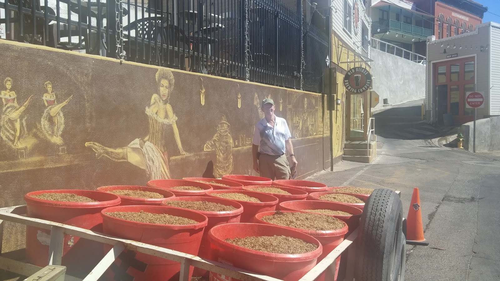
We found our way down and made it to Old Bisbee Brewery for lunch. I got the sampler with 7 beers. One of the most interesting was Salut! which was made for customers who like white wine. Connie ordered it as you see in the tall goblet to the right of me (my glass is in the center). If I look lost in thought with my cell phone it is because I am registering all the beer on Untapped.
While we were eating, the brewery received a delivery of hops.
I am standing in front of the tasting room and the brewery is in the small building behind me.
We enjoyed our trip to Bisbee, but it was time to return to Whitewater to check on the cranes. They had returned! This is only a small portion of the thousands of cranes roosting at Whitewater.
When we were at Whitewater Draw, there was a camera keeping track of the sandhill cranes. The camera has since been disabled because the cranes leave during March for their nesting areas.

Wednesday, March 8, 2017

More of Hot Well Dunes and the Surrounding Area

For our next adventure, we drove into Willcox, Arizona, to visit the Rex Allen Museum.Unfortunately, the museum was closed, even though it was Saturday and the small downtown area was busy. We were able to see the small park dedicated to Rex Allen and his horse Ko Ko.
 Fortunately for Connie and I, the wine tasting room next door was open! The building was originally a bank. The ceiling still has the tin tiles and the floor was the original wood.
 Connie and I enjoyed tasting the wine while the guys waited.
 After our wine tasting, we decided it was time for lunch. We decided on Big Tex's Barbecue. Bob and Larry both got barbecue, Connie got a burger, and I had a chicken sandwich. No one left the table hungry!

 Across the street, was a mural for Willcox. Bob and I have found that many small towns have murals to celebrate their founding.
Before we traveled back to Hot Well Dunes, we stopped at the local Safeway to replenish some supplies. Bob and I also went in Beall's Outlet to look for warm slippers. Nights in the desert tend to be cold in February and March so we needed warmer footwear! 


The next day was a down day for Larry and Connie. They had work to do to prepare for their summer job. Bob and I decided to go geocaching on Mt. Graham near Safford. Instead of taking Haekel Road north to US 70, we drove Tanque Road, which Larry and Connie drove their rig in on! Yes, it is a dirt road.
Once we were on the highway to Mt. Graham, we picked up a couple of geocaches. Bob has an interesting story to tell about a prickly pear cactus attacking him when he replaced a cache.

When we reached the entrance to Coronado National Forest, we snapped a picture of the map for Mt. Graham. Mt. Graham is the snowcapped mountain we see from our campsite.
As we drove up the mountain, we collected a few caches and I have to say we really worked for them as they were above 6000 feet elevation.
We found one near Wet Canyon Bridge which was constructed by the CCC in the 1930s.
The views as we drove up the mountain were amazing! I think we saw our Sol in the distance on the desert floor!
When we reached a trailhead that was over 9000 feet elevation, we decided to turn around and head down the mountain--no way were we getting the cache 200 feet down this trail.
We had a great time caching, but when we returned to Sol, it was too cloudy and cold to go in the hot tubs--the solar run pump had turned off. It was a group decision to visit the hot tubs the next morning before we departed for Whitewater Draw Wildlife Management Area.  The tubs were just warming up, but we had a good soak!
 After showering and packing up camp we moved on to the RV park in Bowie to dump our tanks and fill our freshwater. Time to do some more boondocking at Whitewater Draw Wildlife Management Area.

On to Arizona!

From the rest area in Anthony, New Mexico, we got an early start. Our plan was to stop in Deming, New Mexico, at Wal-Mart to pick up what we would need for boondocking in the middle of no where for several days. We also needed to find a lumber store so we could get a 2 x 4 to brace our closet rod. It was only a matter of time before the center support pulled out of the ceiling and it did just that on our way from  Stockton to El Paso. The rod goes most of the width of Sol in the back and the center support was held up with just four small screws in the ceiling, nothing was used to reinforce the ceiling where the support was attached.

We found our way to the Deming Wal-Mart and realized that there was a home improvement store just a few blocks away. We accomplished our mission and then we were on the road again. Our next stop was for lunch and to fix the closet rod. We pulled off the rest area near Gage, New Mexico. It was a nice area with picnic ramadas set around a loop. Bob found a place where we could put the jacks down and put out the bedroom slides so he could measure the length he needed to cut the 2 x 4. After he got it cut, he notched the top to fit the rod and we were once again hanging clothes in the closet!

We were not far from Arizona so I texted our friends Larry and Connie to find the best way to get to the campground where they were staying. Of the three ways in, we chose the paved road which meant we had to get off the interstate at Lordsburg and head northwest on US 70. Just short of Safford, Arizona, we turned south on a local road that took us out into the desert 25 miles. Our destination was Hot Well Dunes BLM area.

 Site number 3 was open next to Larry and Connie so we were set for the next five days!
After getting set up it was time to go to the hot tubs! In the 1920's someone was drilling for oil and hit a hot spring in the middle of the desert. Today, the spring feeds two cement tubs during daylight hours. Over the years, the level of the spring has diminished so now solar panels power the pump which fills the tubs with hot water.  The solar panels are on the slanted roof of the brick building behind this tub.
It was our plan to enjoy the tubs at least once each day as long as the weather permitted during our stay.
Connie and Larry waited to visit Fort Bowie until we arrived. Bob and I visited it on a previous trip west, but we really enjoyed the hike to get to the fort. If you have physical limitations, you can get special permission to drive to the fort, otherwise, it is a 1.5 mile hike to get to the fort and another 1.5 mile hike back to the parking area. When you add all the side trips to see exhibits along the way, the hike is closer to 5 miles.

Along the way you pass the Butterfield Stage Coach stop, a cemetery, the foundation of a miner's house, and several Native American exhibits. This wiki-up is located near Apache Springs.
 This is Apache Spring which was the cause of much fighting in the 1800's. In the desert, everyone wants control of the fresh water.
We walked around the ruins of the fort before heading back on the ridge trail. This picture overlooks the visitor center which is at 5000 feet elevation. The spiky plant is an ocotillo. When it gets a little water, it is covered in green leaves and you cannot see the spikes!
We took advantage of the bench on the overlook trail for photos. The tallest mountain behind us was used as a heliograph station by the army. They used a mirror to send messages to Ft. Huachuca, 90 miles west.
It was a sunny, warm day, just right for a hike before lunch.
Unfortunately, the next day was not as nice. Our tour that day was to Chiricahua National Monument, one of my favorite places. Once we got into the Chiricahua Mountains, it was cold and windy. Larry drove us to Massai Point at the top of the mountain. We were able to hike the short nature trail before the cold got too bad.
Chiricahua is literally an 'island in the sky.' As you drive to Chiricahua the desert looks just like the pictures of Ft. Bowie, but once in the park you see fabulous rock formations!
We didn't stay long in the cold, but we enjoyed the views and snapped a few pictures.
 It was time to head back to Hot Well Dunes and hit the hot tubs! Boy, did they feel good that day.

Tuesday, March 7, 2017

Westward Ho!

As we continued our journey west, we got off the beaten path (I-10) to explore Fort Lancaster Texas Historical Site.  The fort is located off Texas 290 near Sheffield. Yes, there aren't many roads heading due west in west Texas, but we found the road to Fort Lancaster. This fort is the only one in Texas that was attacked by Native Americans in the 1800s.
 I think we were the only visitors to the site that day. The historian in the visitor center said the site gets between 0 and 25 visitors a day. The total for the year is around 3200.
 As with most old forts, the buildings were torn apart by locals who used the materials to build their own homes. Some buildings still have their foundations, but some are completely gone.
 Behind the visitor center we found a stage coach. The steps were wobbly and it was hard for me to imagine a woman traveling in a long dress getting in and out easily.
After a picnic lunch and grabbing the geocache at the entrance, we continued west. The interstate doesn't offer many good places to stop as you travel west so we decided on Fort Stockton---home of the large roadrunner. There was a Wal-Mart where most travelers spend the night, but we chose Pizza Hut. There was a large lot behind the restaurant where RVers could park. Guess what we had for dinner? Pizza, of course!

The next day we were headed toward El Paso with the intention of stopping at Hueco Tanks State Park. As we traveled, I tried to call to find out if there were sites open and how large a vehicle they could accommodate. I kept getting a recording so we kept driving.

It was time to feed Sol so we had to find a diesel station where Bob could easily maneuver in and out. We didn't find one until we were at the base of the mountain on the east side. When Bob got out to feed Sol, the wind was really strong.

After filling the tank we continued over the mountain pass. The wind was really whipping tumbleweeds across the road and the dust was getting thicker. Sol began to be buffeted by the wind and we knew we wanted to find a safe place to stop. Luckily, as we came down off the mountain the road led directly to the outlet mall which has a huge parking lot. Several semis were already pulled over and we joined them. The wind warning was for gusts up to 65 miles per hour. We decided to stay put and relax until the winds died down.

Later that evening, we decided to leave to drive the short distance to Anthony, New Mexico, where we stopped at the Welcome Center. Our trip across west Texas didn't take as long as expected...

Next stop---Arizona!

Saturday, March 4, 2017

Enjoying Hill Country in Texas

Texas Hill Country is a popular destination on the weekends so we decided to visit more state parks to hike and geocache on Friday. Our first stop was Old Tunnel State Park. From May to October this park is home to bats. The tunnel was once used by steam engines to make the climb from southern Texas to Fredericksburg. Now, it is empty during winter months and filled with bats in the summer!
 Here we are on the trail between the upper and lower viewing areas. Only 250 people are allowed in to view the bats on a summer evening.
 One of our geocaching spots had a clue saying the cache was near Texas 'kitsch.' Well, we found it, the cache and the kitsch--a Lone Star Christmas Tree!
 The next stop for hiking and geocaching was Guadalupe River State Park. Due to the rains the weekend before, the trails had been closed to all traffic until the day we arrived and they were open to hikers only.
 We spent most of the late morning and early afternoon hiking and caching. The weather was beautiful and we enjoyed our time at Guadalupe River State Park. We never got close to the river while we were hiking! From Guadalupe, we went to Blanco, Texas, to Real Ale Brewery. Since it was Friday afternoon, the place was packed! Bob and I enjoyed a beer before heading back to the fairgrounds for the evening.

Saturday we spent walking and sightseeing in Fredericksburg. Admiral Nimitz's birthplace has an historical sign on a prominent street corner and The National Museum of the Pacific War is located across from the visitor's center.  The place was packed with tourists for the weekend and there is so much information that your ticket is good for three days! Outside is a memorial garden and a Japanese Peace Garden.

Sunday was a chore day. We did some grocery shopping and some cleaning of Sol, inside and out. Late in the day we ventured back into Fredericksburg to purchase some fudge to accompany the port we bought at the winery and to have a German pretzel at the brewery.
This was the most time we had spent in Fredericksburg during our travels and we thoroughly enjoyed it. Monday would be a travel day----time to see west Texas!