
The next cache was about .4 of a mile along Otero Trail. It was an easy find. We continued on for another half mile to look for the last cache. This one was more difficult. We searched the area for 20 minutes, starting at the coordinates and then moving out to find the cache. The cache was 52 feet from the coordinates. When we logged the cache, we gave the coordinates where we found the cache. Hopefully the person who placed the cache will correct the coordinates or move it to the original coordinates.
We didn't know if the trail was a loop, so after walking about 1.5 miles, we retraced our steps to the trailhead. We stopped to rest along the way.

We passed many other hikers and mountain bikers during our hike.We collected one more cache that was a short hike from the road, then returned to a picnic area we had seen earlier to eat our lunch. It was about 3 in the afternoon, so we decided to head back to the rv.
We have a special guard at our campsite--a bunny. There are many bunnies in the campground, but this one seems to stay at our site.
 Spring is here! The crepe myrtle at our campsite is blooming! If only the spring winds would die down! We watch the wind speeds daily. We don't want to drive the rv if the winds are going to be too strong.
 Monday, March 31, 2008
The Turquoise Trail was recommended by several people. It is a scenic byway to Santa Fe. We drove north along NM14 toward Santa Fe. We passed the east side of Sandia Peak (tallest peak in Albuquerque). The ski area closed March 16, but there is still snow on the mountain.
Our next stop was Madrid (MAD-rid). It is a village of 'artists' which started as a mining town in the 1800's. It almost faded away until hippies of the early 1970s began to make it their home. Now, I don't know what you think of when you hear hippies, but Bob and I think of people that want to live with nature and stick it to the man or corporate America. That may have been the case in the early 70's, but now it is every man for himself!
Madrid is an artists' enclave. The village is small. When you enter from the south you pass the village dump area! It is next to the highway near an arroyo (dry stream bed). We think they are waiting for the spring flood to carry all their old furniture and trash away!
The village itself is on the road and goes for about 1/4 mile. There are shops along both sides of the road. They sell herbs, teas, clothing, pottery, jewelry, furniture, handmade rugs and other artsy items. The textile shop has native American rugs, Mexican rugs, and Tibetan rugs. Throw pillows are also available. The least expensive item in the shop was a throw pillow for $65. The rugs were over $2000.
 Next to the textile shop was an interesting work of art.
There were a few stores with wind bells and fountains. I liked the fountains, but they started at $2750 with an additional $1000 for installation. Bob and I figured we could buy the tools to make cut the granite stone and still have $2000 in our pockets. We would install it ourselves, thus saving another $1000!
 The most interesting item about Madrid has to do with a recent movie that was filmed in the area. If you saw the movie "Wild Hogs" you may recognize Maggie's Diner!
 The diner was built specifically for the movie. It is a movie set, and only a movie set!
From Madrid, we drove to the village of Cerillos. It reminded us of Pino Alto northeast of Silver City, New Mexico. Cerillos was very small. It had several antique shops (closed until later in the season), a general store, and a petting zoo. Cerillos claim to fame also has to do with the movies and television. Disney made six episodes of 'Nine Lives of Elfego Baca' which were combined into a feature film in Europe. The movie 'Young Guns' was used Cerillos for a portion of its filming. The village has over a thousand years of history. http://www.legendsofamerica.com/NM-Cerrillos.html
From Cerillos we drove into Santa Fe. It also has a lot of history. We walked around the downtown area, looking at the local merchandise. The city was built around an historic plaza.
Even though it is a city, all the buildings are pueblo style. There are no high-rises!
After looking around the city center, we drove to the O'Keefe Museum. ( http://www.okeeffemuseum.org/ ) Georgia O'Keefe spent much of her later life in New Mexico. There is even a scenic drive, O'Keefe Scenic Byway, which goes northwest out of Santa Fe to Ghost Ranch and Pedernal.
We returned to Albuquerque along NM 41. There was one village along the highway, Galisteo. We didn't stop as it was late in the afternoon and nothing was open (it was also an artists' enclave).
We will be in Albuquerque until Thursday. We haven't decided where we will go after Albuquerque--we found out the fam-camp in Flagstaff is closed for renovations. We may head north to Navajo Lake State Park. We'll let you know what we decide.
Thank you to Jennifer, Andy, Amy and Cecil who have posted comments on our blog. We answer these comments on the blog, so if you post a comment, please check back for our reply! (Just check anonymous if you don't want to enter any personal information!)
 There were 3 pig races during the day.

 We bought 10 Barbecue Bucks and tried samples at 6 different booths. Then we split a barbecue sandwich that was pretty good.
 As we were leaving we found out why the parking lot was so packed. The Disney Nemo Ice Show was playing in the civic center. The show was over as we were leaving the Pork and Brew.
 It was interesting to see how flight got started. They had china from the Hindenburg. Also on display were plates from the 1780s commemorating several balloon flights in Paris.
 The gondola's on the first balloons were not very large. Bob and I fit in this one with a little room to spare.
 This is a replica of the Double Eagle V which successfully crossed the Pacific Ocean.
 Except for difficulty with street signs, we had a great day!


 The next two pictures were taken from the same spot just looking in different directions. We are standing halfway to the top of the trail.


 We saw more graffiti at this park than at Three Rivers. It may be due to the proximity of a city with a large population. The site was not protected until the 60s. Many people carved initials and their own pictures near the petroglyphs. The graffiti is easy to discern from the real petroglyphs--shading is the clue.


 The area looks like a beach town complete with vacation houses (adobe with flat roofs), sandy beaches, and rv/boat storage areas. It is definitely not something you would expect to find in a desert area.


 After eating our lunch, we hiked across the county road to take a look at the village which is partially reconstructed. It was a bustling center for trade around 1300, but by 1400 it was abandoned. The Mogollon (muggy-OWN) who lived there have no identified descendants. It makes you wonder what happened to them since they had been in the area for so long. The Mescalero Apache were the next inhabitants of the area.
 We don't remember the hiking trail from 1978, but we did remember the white, white sand which is actually gypsum.
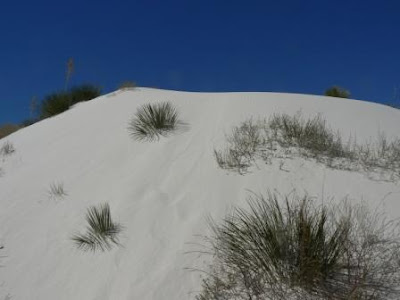 Along the hiking trail we saw a bush that had formed a natural flower pot. The roots go deep into the gypsum so when the wind blows, the bush stays in place. As the dune moves, the plant and gypsum stay until the bottom looks like a giant flower pot.
 Amid all the white dunes there are cottonwood trees growing. They are found in an area where the water table is about 25 feet deep.
 We found the answers to a couple of questions so we were able to log a geocache at White Sands. We had to have a picture of us with the dunes in the background to complete the cache.
 The trail was steep and rocky. This is a picture of a relatively level portion of the trail.
 The elevation rose 600 feet in the first .6 of a mile of the trail.
 Even though Wednesday was the first day of spring, we only saw a few wildflowers growing among the rocks.

 We continued a little beyond the 1.5 mile post and the trail began to climb again. We stopped at an elevation of 5142 (on our GPS unit). At that point we were about halfway to the peak.
 The hike down the mountain went much faster. We passed several people who were trekking up the mountain.