We packed a picnic lunch and headed for White Sands National Monument. We visited White Sands in 1978 when Bobby was about 8 months old. As far as we could tell the only change is the number of visitors per day. It was pretty crowded as Friday was a holiday for many and they were taking advantage of the beautiful weather to visit this monument.

 We don't remember the hiking trail from 1978, but we did remember the white, white sand which is actually gypsum.
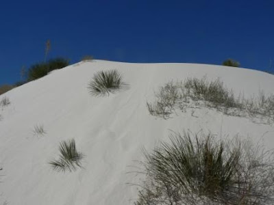 Along the hiking trail we saw a bush that had formed a natural flower pot. The roots go deep into the gypsum so when the wind blows, the bush stays in place. As the dune moves, the plant and gypsum stay until the bottom looks like a giant flower pot.
 Amid all the white dunes there are cottonwood trees growing. They are found in an area where the water table is about 25 feet deep.
 We found the answers to a couple of questions so we were able to log a geocache at White Sands. We had to have a picture of us with the dunes in the background to complete the cache.
After visiting White Sands, we went to Holloman AFB. The entrance near housing was lined with American, German, and New Mexican flags. Germany has a flight school for its air force at Holloman.

 The trail was steep and rocky. This is a picture of a relatively level portion of the trail.
 The elevation rose 600 feet in the first .6 of a mile of the trail.

 Even though Wednesday was the first day of spring, we only saw a few wildflowers growing among the rocks.


The buildings are relatively new. The one old barrack that we saw was in the process of being knocked down to make way for a new building.
The BX was brand new, but the commissary was old and relatively small. It still had the good bargains that we are accustomed to finding in commissaries.
We returned to Oliver Lee Memorial Park for a restful evening and an outstanding sunset.
Saturday, March 22, 2008
Saturday we decided to hike part of Dog Canyon Trail. The trail starts in Oliver Lee Memorial Park and continues into Lincoln National Forest. The trail is over 5 miles long (one way). To hike it to completion and back to Oliver Lee takes over 10 hours. No, we didn't to the whole hike. We went a little over 1.5 miles up the mountain before we turned around and headed back to camp.
This is a view of the campground from the trail just above the visitor center. Our rv is in the center toward the far of the campground.
The trail was steep and rocky. This is a picture of a relatively level portion of the trail. The elevation rose 600 feet in the first .6 of a mile of the trail. We saw some spectacular sights along the way. Here is a view of the campground from further along the trail! Our rv is on the right, just before the curve.
Even though Wednesday was the first day of spring, we only saw a few wildflowers growing among the rocks. There were the usual ocotillo, prickly pear cacti, sotol, and soaptree yucca along the trail.
We rested often on the way up as the climb was steep for the first .6 mile. Then the trail leveled off and we had an easy hike to the 1.5 mile post.
White Sands was visible to the west of Dog Canyon.
 We continued a little beyond the 1.5 mile post and the trail began to climb again. We stopped at an elevation of 5142 (on our GPS unit). At that point we were about halfway to the peak.
 The hike down the mountain went much faster. We passed several people who were trekking up the mountain.
We continued a little beyond the 1.5 mile post and the trail began to climb again. We stopped at an elevation of 5142 (on our GPS unit). At that point we were about halfway to the peak.The hike down the mountain went much faster. We passed several people who were trekking up the mountain. We feel like we are almost back to our regular selves after our bout with the flu.
No comments:
Post a Comment