Monday, May 29, 2017

Caudalie Crest Winery and Farm, Westson, Texas

Our travel day was long, but we had called ahead to Caudalie Winery and Farms to let them know we would be arriving that afternoon. Caudalie is a member of Harvest Hosts. We chose this winery for its close proximity to McKinney, Texas where we would go the following morning with Sol to have her front windshield measured for a day shade to go along with the night shade she already has.

The route was not too bad, we traveled major US highways until about 30 miles from the winery. Our route took us through the winding streets of Weston, Texas. All I can say is they need to trim their trees!

After we arrived at the winery and got set up, we walked over to the barn to see the animals.
 George was enjoying some down time. Ringo looks just like George, but has a very light gold mark on his muzzle. Yes, they are named after two famous singers.
These baby goats felt safe on the bale of hay. The others were rambunctious, fighting over their food.
 This guy enjoyed watching us as much as we enjoyed watching him and the antics of all the others.
Later in the evening, Bob and I went to the tasting room for a private tasting. We enjoyed talking with Ray and Sue and learning about their winery. We tried six wines and found them all to be excellent. We chose a bottle for Bob's mom and called it a night.

The next morning we made our way to McKinney and MCD Innovations for Sol's measurements. Luckily, MCD was only 5 miles from the winery! After Sol was measured and Bob felt comfortable with the instructions for mounting the new shade (it would be custom made and mailed to us), we started our trip north. We planned to stop somewhere in Oklahoma for a few nights before heading to Arkansas.

Thursday, May 25, 2017

Copper Breaks State Park, Quanah, Texas

Every time Bob and I travel through Texas, we have to remember just how HUGE the state is compared to others. Our travel day was about  180 miles long from Fritch Fortress at Lake Meredith to Copper Breaks State Park about 8 miles south of Quanah, Texas. We traveled US 287 for most of the way and found that each county we passed through had an excellent rest area. The only problem with the one in Donley County was the sign by the door to the ladies restroom: BEWARE OF RATTLESNAKES!  Not my favorite sign EVER! Fortunately Bob nor I saw one.

Once we arrived at Copper Breaks State Park, we were told to find an unoccupied site and return to the office with the site number after we were parked and settled. Contrary to what we had heard, the campground had quite a few campers. We found site 13 to be just right for Sol.
 What you can't see in this picture of me relaxing after a 'long' day is the picnic teepee behind Sol. These are the first shelters shaped this way that we have seen while camping in any of the states.
 Besides other campers, we were able to watch a lot of wild life while sitting outside. This rabbit was not sure if he wanted his picture taken, but he stayed still just long enough.
The big tree across from our site always had a roadrunner somewhere near. Often times there were mockingbirds chasing it. When that happened, he ran under the bush.
Bob and I got in a couple of hikes during our short stay. This field of wildflowers had passed its peak, but it was still pretty.
 There were steps along the canyon trail.
Now when we went geocaching along Powerline Trail in the park, we found the geocaches, but we also met up with one of those nasty critters called a rattlesnake. We had already been down the rock trail and were on our way up when Bob caught sight the critter in his peripheral vision at the same time it started rattling. The critter struck, kept rattling, Bob jumped back to where I was and we were both very still. The critter kept rattling and we walked WAAAAAAY around the area he was guarding. He didn't strike again and we increased our pace to get the H out of there! Once back in Sol, we researched just how far a critter like that can strike when coiled and it is up to 1/2 of its length. You'll be glad to know that we gave him about 20 times his length when we walked around the area.

The critter encounter didn't stop our hiking the next day, but we were extra vigilant. We walked a nature/mountain bike trail. From one of the higher view points, we could see the lake formed when the Pease River was dammed.
Near the end of the trail we found a ramada to relax in and enjoy the view. We were thankful we had not seen any more critters.
The following morning, we were off again to our next destination. It would be a long drive for us, but we needed to get close to McKinney, Texas, to get Sol measured for a front sunscreen.

Tuesday, May 16, 2017

Amarillo, Texas--New Adventures

Our drive to Amarillo was another long day for us. We weren't sure where we were going to stop. Palo Duro Canyon State Park south of Amarillo always entices us, but we have never been to the campground and Texas state parks don't allow you to select a site when you make reservations. We didn't want to drive into the second largest canyon in the U.S. to find the campsite was not one we liked. Once we got to the Texas Information Center in Amarillo we decided to head north to Lake Meredith National Recreation Area. It offered free camping with a dump and fresh water nearby. There are many camping areas in the NRA, but we chose Fritch Fortress. The view was amazing. Not long after we arrived and set up, the rains came. Oh, no, more hail! We pulled in the slides so the toppers wouldn't get any damage. Thankfully, once again, the hail was small so the car and Sol were safe.
 I called the next morning and made reservations for the tour at Abilates Flint Quarries National Monument which is in Lake Meredith National Recreation Area. The tour didn't begin until 2 so Bob and I had the morning to explore Amarillo. We began with a trip to Jack Sisemore's RV Museum at his Traveland RV Center.  Over the years he has collected and restored RVs, camping equipment, and motorcycles. It was an interesting place. I enjoyed seeing the Coleman camping equipment as my dad sold Coleman products and furnished Bob and I with a lot of camping equipment when we were first married. We had the green lantern and....
 we had the folding table with four camp stools that fit inside. It was a heavy table. We also had a green Coleman cooler and campstove.
 One of our favorite restored RVs was the Flxible bus used in the movie RV.
 This 1948 bus was modified for Grenicke movie family.
 This old Ford had a side air cooler for travel in the desert. It is like 'swamp coolers' used on houses in the desert and is water cooled.
 One of my favorites was the camping kit that came complete with all the equipment needed to turn a standard Model T into a driving camper! The kit was made by Anheuser-Busch! 
This is one of the original towing campers that could be raised and lowered. Bob's dad had one of the later model marketed as a HI-LO.
 To raise or lower this camper, you had to the turn the wheel located near the front hitch.
 We enjoyed seeing all the old RVs and camping equipment, but we had to get back to Abilates Flint Quarries. But wait, we needed some lunch first. Where else would you go in Amarillo but The BIG Texan? Yes, we went in and due to the long lines, we sat at the bar and had an appetizer before driving to the quarries.
 Bob and I both thought the quarries were named after the type of flint, but they were named for the ranch hand who discovered them. As you walk up the mesa where the quarries are located, the area  looks like the rest of this part of Texas: red dirt, rocks, mesquite trees and cacti. When you reach the quarries, you see pieces of flint laying everywhere. This is one big chunk of flint. The first people in the area found the flint and were able to trade for things they needed. This area became the 'Flint Mercantile' for many people. An interesting fact is that with all this flint, not one arrowhead was ever found in the area. Spearheads for hunting were found, but no arrowheads.
 One of the plants the guide pointed out for us was this antelope milkweed. It is one that monarch butterflies love. I thought the flowers were an interesting shape before they fully bloomed. The one in the front has bloomed, not the others.
 After our guided hike, it was back to the campground.
 Sol was waiting for us, wondering if we would put the slides out or if another storm was on the way.
There were no more storms so we spent a quiet evening enjoying the view.  The following day we drove around the area, but the trails around Lake Meredith were too wet for hiking or geocaching. We spent the afternoon plotting the route to our next destination and when the temps cooled,we walked around the campground.

Sunday, May 14, 2017

Santa Rosa Lake State Park, New Mexico

Just like we usually do after boondocking, we look for a place to empty our tanks and fill our fresh water. The fresh water fill was just two sites away from ours at Bluewater. The dump, however, was at the entrance to the park. We got Sol's fresh water filled and were off to dump--or so we thought. Bob got Sol lined up just right, connected the sewer hose to the dump, I put my foot on the hose to keep it in the hole and then Bob opened the valve. UGH! The dump was full or clogged and everything backflowed. I yelled for Bob to shut the valve which, thankfully, he did immediately. Not only was 'stuff' oozing out of the ground where we were, it was also coming out of the other sewer hose connection on the the other side of Sol! We got our hose rinsed out and put away, but the dump was YUCKY! Bob and I made sure there was nothing on our shoes before going in Sol. I got my sticky notes out and wrote signs for the dump to warn others. I hope those signs didn't blow off in the wind.....

Then it was on to Santa Rosa Lake State Park. On the way we needed to find a place fill Sol with propane. When you are boondocking and you have a residential refrigerator, you don't use nearly as much propane! Sol hadn't had her tank refilled since we picked her up over a year ago! Bob also wanted to top off the diesel. We found a place that sold propane in Moriarty, New Mexico--King Butane. After that, it was off to get some diesel. Using GasBuddy we decided to try Lisa's Truck Services on the east end of town. Their diesel was priced quite a bit lower than the other stations. While I was waiting for Bob to fill the tank, the cashier asked it we were new to the area and told me the restaurant was really good. I had been watching people come and go as I waited to pay for the fuel and it seemed to be quite a popular spot for locals. Bob and I decided to eat at Lisa's and we really enjoyed it. His hamburger was almost too big to eat and my Albuquerque Turkey was excellent. We recommend Lisa's to anyone traveling through Moriarty.

We finally made it to Santa Rosa, got set up and the rains came. Unfortunately, with the rain came hail! Bob and I hunkered down and watched the weather. The hail was relatively small and didn't do any damage to Sol or the car. As you can see we have a nice spot--no hook-ups, but that was fine with us.
The next day we drove into Santa Rosa to see what had changed. I think a lot of the local restaurants have closed and there are more fast food chain places. We drove through one of the local parks, the area is known for its lakes, especially The Blue Hole. The weather was holding and we wanted to hike the lakeside trail back at the park so we headed back toward the campground.

First we went to the dam overlook.
 Then we walked the upper level nature trail.
Along the way we saw some different flowers on the trail.
We also had a good view of the control tower for the dam.
This lake was made when the Pecos River was dammed. As with most of the lakes in New Mexico, this one has a low water level. This is the Pecos as it leaves Santa Rosa Lake. This was taken at on overlook on the upper nature trail.
Then it was on to the lakeside trail. It wandered around the rocky shore for about 2 1/2 miles. In several places we saw people fishing, but we didn't see them catch anything.
We enjoyed our hike, but as you can see, the clouds are building in this photo. We made it back to Sol before the rains arrived.
Once again, it rained for most of the afternoon and evening. And yes, once again there was hail. Thankfully, there was no damage to Sol or the car. The next day would be a travel day. We were headed toward Amarillo, Texas, but weren't sure where we were going to park. Stay tuned to find out where we landed.

Saturday, May 13, 2017

Hiking at Bluewater Lake State Park, New Mexico

There are two units of Bluewater Lake State Park, Las Tusas, which is tent and primitive camping on the west side of the lake and Stoneridge which has primitive sites, tent sites,improved sites and electric sites on the east side of the lake.  Water was available throughout the campground, but none at any sites. Bob and I were in Stoneridge at an improved site (no water or electric, but a picnic table and firepit/grill). Not far from our site was one of the trailheads for Canyonside Trail.
 This trail followed switchbacks down the side of the canyon to Bluewater Creek.
 We chose to change trails after we crossed the creek on the rocks and log.
 Dam Trail went south along the creek almost all the way to the dam which forms Bluewater Lake.
 Water was pouring from this pipe in the dam. The ground was a bit too soggy for us to get too close to the dam or for us to cross the creek to get two geocaches hidden on the opposite shore.
In many places you couldn't see the water for the reeds, but you could hear it as it moved downstream.
 We retraced our steps to the log where we left Canyonside Trail and continued north on that trail. Once again we had to cross the creek. This time it was on well-placed rocks.
 Once across the creek, we were in the midst of birds flying every which way, building their nests on the canyon wall. As long as Bob and I were still, they didn't mind us watching them work.
However, when my phone made noises after I took this video, they came swooping at us from all directions!
We finished our hike by finding the cache located near the creek at the edge of the park. From there we walked through Canyonside Campground and back to Sol.
Later in the day we hiked Dam Overlook Trail. It gave us a good view of the dam.
                                     
 At one time there was a building above the dam. Bob and I couldn't decide if it was a house or an office.
Bob and I enjoyed our time at Bluewater Lake State Park, but it was time to move a little further east. Our next stop was a place we stayed once before--Santa Rosa Lake State Park, New Mexico.

Friday, May 12, 2017

Bluewater Lake State Park, New Mexico

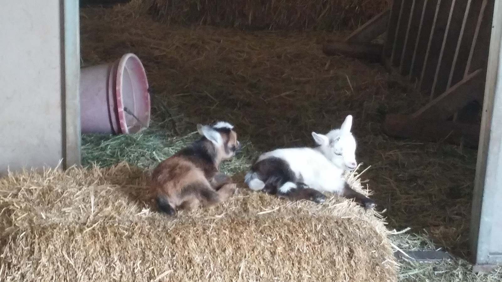
Since our last travel day was only 25 miles, we decided we needed a long day to make up the miles. Off we went for a whopping 230 miles to Bluewater Lake State Park near Prewitt, New Mexico. From this base camp we wanted to explore Grants and other nearby sights. When we entered New Mexico, we stopped at the welcome center to gather materials on the area. We found lots of information, but no brochures about the national monuments in New Mexico. We continued our trip to Bluewater Lake, but right at the entrance to the park, these fellows decided to slow us down!
Once in the park, we unhooked the car to drive around the campground and find a good site since we weren't familiar with the park. We found one on the ridge--we had views of the mountains to the east over the canyon and a view of the lake to the west.
It was time to relax and enjoy after a long day on the road.
The following day we geocached our way to Grants and then drove NM 53 to El Malpais National Monument and El Morro National Monument. We thought about walking this trail, but it was 7.5 miles one way across lava rock. Hmm, there has to be something a little easier and shorter in El Malpais.
About 10 miles down the road, we found the visitor center and something unusual for us to do! There were caves at in the El Calderon area--wild lava caves. We asked the ranger for information to obtain a caving permit and she gave us a permit after deeming us fit for the caving experience. We put caving on our calendar for the following day!

We continued our drive on NM53 to El Morro national Monument where Inscription rock is located.
Bob and I decided to walk the trail to Inscription Rock and then go look for a place to eat lunch. The trail was almost a mile. Here Bob is standing at the trailhead behind the visitor center--the rock is in the background.
 Here I am a little closer to the rock.
 At the base of the rocks is a tank or natural holding area for the water that drips off the rock formation. The black marks show the water trail. When explorers and Native Americans traveled through this area, this was the only water for many miles.
As they rested and replenished their water supply, the explorers carved intricate messages into the sandstone. This is not the oldest one we saw, the oldest known Spaniard signature was dated 1604. Unfortunately, many of the signatures are disappearing due to erosion of the sandstone.
Later, the Americans carved their signatures and dates.
There was another trail, but since it was past lunch time we decided to drive on---unfortunately we didn't come to a town with a restaurant until we got to Gallup! It was a very early dinner for us!

When we returned to Sol, we got everything together that we would need for our caving adventure the following day--flashlights, batteries, bike helmets, and windbreakers.

Then next morning, we were off to El Calderon to do some spelunking and to hike the crater rim trail. Yes, we took a lunch with us this time. This is the entrance to Junction Cave. I think getting down into the cave was the most difficult of all. This is a picture straight DOWN into the mouth of the cave.
Once in the mouth of the cave, you had to limbo through a metal grate. If you didn't fit, then the cave wasn't for you. There was a marked trail to help you through the cave. The white you see are the backs of the reflectors marking the trail--going in they are red, out they are white.
Since this is a lava cave, it is not wet, nor does it have stalactites or stalagmites. As the lava dripped as it dried. The dripping lava on the ceiling is rather sharp and one of the reasons for the bike helmets. The other reason is low ceilings!
In several places we had to climb over lava rocks and then crawl on our hands and knees to get to the next room.
Bob and I took a break for a photo op. We are a little blurry because the camera had to focus in complete darkness!
This was one of the areas where we had to stoop to get through to the next area.
At the point pictured below, Bob and I decided we had seen enough of the cave. To get to the next room you had to belly crawl over the rocks in one of these arches. We were almost to the end of the cave so we turned around and headed out.
 This is a view of the mouth of the cave as we were exiting.
Here I am, almost to the top! It was a great experience and if you aren't afraid of the dark or small enclosed spaces, give it a try!
Time to walk the rim crater trail (after returning our caving equipment to the car). The rim trail was about 5 miles. As we started our hike, we passed by the opening of Xenolith Cave. It was a little deeper and longer than Junction Cave, but it was also rated difficult so we kept hiking.
As we neared the crater area, we came upon the lava flow trench.
To get to the top of the crater, we had to walk some steep steps up the side. I am about halfway to the top!
 Once at the top, we had a great view of the area. And yes, the cinders and ashes were red.
 We walked around the rim before descending on the switchbacks.
 From the top, before we started the descent, Bob took a picture of the steps we climbed on the other side of the rim. You may need to click on the photo to enlarge it enough to see the steps.
We continued on our way toward the parking area. About a mile from the parking area, the Continental Divide Trail joined our trail.
 We enjoyed our day of spelunking and hiking. Our next adventure would be at Bluewater Lake State Park's trails.