Our drive was pretty uneventful until we were on US highway 20 from Corvallis to Newport. There was road work and we were stopped by a flagger for 55 minutes! The traffic traveling east was not stopped nearly as long as we were. Bob and I counted around 40 cars going west before our lane began to move and then the flagger stopped our lane after 10 cars!!!! We counted another 50 vehicles going east before we began to move again. As we neared the flagger Bob let me know that if the flag turned to "stop" as we neared it, we were going anyway--I was with him all the way! Did I tell you I got out and stopped vehicles behind us? Well, I did as we were on a blind curve when we first stopped and there was no way for people to know we were stopped just out of sight. What a day!!!!
We finally made it to US 101 on the coast--we saw the familiar Yaquina Bay Bridge and the Pacific Ocean. We traveled about 20 miles north to Highway 229 where we turned right after crossing the Siletz River. Our campground was only 1 1/2 miles away. What a relief to arrive. This is the longest travel day we have had in quite a while.
Our site is right on the Siletz River. This is a view from the front of the rv.

And here are two views from the rear of our rv!

 As we checked in, the owner of the park told us this is a great river for kayaking!!!! Could it be??? Are we actually going to use the kayaks we have toted for all these days (244)!!! I hope so! We are going to be here for a week so kayaking & fishing are definitely on our list of things to do.
Bob was just glad to park and relax after we arrived at Coyote Rock.


 It would be our stopping point for exploring Crater Lake National Park.


 Jacksonville is a national historic landmark town. We walked around the main street and looked in shops, but it was very hot! We have gone from the cool redwoods to an area with record breaking heat!
  Thursday we will move north along Interstate 5 to Sutherlin, Oregon. There is an Escapee Park there where we would like to stay. We are members of the Escapees (the group we were with at Quartzite, Arizona).
  Letter Loop and Ellsworth Loop were on our list of things to do. The trees and the area are amazing. It is one more of the temperate rain forests we have visited this trip--the Cascades and Cape Perpetua are the others. The trail was well marked and well used.
 Bob found a gnarly tree that may soon have another tree growing from the burl.

 We returned to our campground a decided it was time to eat at the lodge. We walked over early in the evening and had a great meal--Bob had steak and I had beef tournados.
 As we walked back to camp, we took a picture of another of the CCC buildings still standing at Patrick Creek. This was near the swimming hole the CCC built. The wall that delineated the swimming hole was washed away in the flood of 1964.
 You can walk through the swimming and fishing area and along the rocks near the creek.
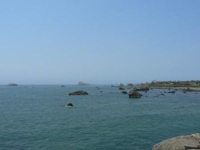
 Here is the view to the right of the monument sign. It was a bit hazy due to the fires further south in California.
 The parking area was 300 yards from the Chateau. Most parks call their inns lodges, but at Oregon Caves it is The Chateau.
 We looked around the Chateau for a while then went to get our names on the list for a cave tour. The trail in the cave is 1/2 mile long and the tour takes 90 minutes. One thing we found out about caves at high elevations is that the constant temperature is lower than that in caves in Virginia, Kentucky, and Missouri. This cave is a constant 42 degrees! Of course we were so excited to finally have warm weather that neither of us brought our windbreakers! Oh, well. We have to have something to complain about.
 Roots of the trees surrounding the cave only grow about 15 feet deep, but one had to be different. Its root was found 55 feet down in the cave. The tree is no longer standing, but the root is still in the cave.
 We didn't see many of the formations that we usually see--stalactites and stalagmites. We did see marble and limestone flows. We saw a lot of formations in one room--the paradise room. It was a small room at the top of 45 steep stairs. In the middle of the floor was about 2 inches of water. One poor lady had on her pretty summer sandals and very frozen feet!
 Besides being cold, this was also the wettest cave we have visited.
 As we left the cave, I was reminded of the hanging gardens at Zion National Park. There were flowers and ferns growing on the sides of the rocks at the cave exit. These caught my eye because of the colors--green, yellow and red--all on the same plant.
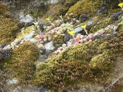 We exited the cave at a higher elevation than the visitor center. We went back to the car and ate our lunch.
  From Oregon Caves we retraced our steps almost to Cave Junction. We turned off on Holland Loop Road as there are 3 Oregon wineries along the loop. We visited all 3 and tasted reds and whites. As we drove back through O'Brien, Oregon we saw the sheriff waiting to get those with out of state plates. We were prime suspects as we had Florida plates. Oh, well. It was a great photo opportunity. (The car is an exhibit in front of the local gas station).
 The attendant topped of the tank of the CRV and we continued back to our campground. Hmmm......
 This is Patrick Creek for which our campground was named.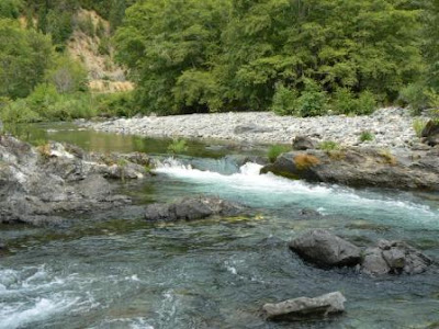
 We didn't find any so we drove about a hundred yards down the road to Myrtle Creek Trail. It was an interesting trail as it followed an old mining ditch used to run a hydraulic monitor during mining days. The monitor blasted out huge areas of rock and sand with an enormous stream of water. The trail had signs pointing out different flora of the area and remnants of mining equipment. Some of the equipment is on the National Historic Register! Hard to believe since most of it is rusted and rotted!
 We decided to geocache our way through Redwoods National Park in northern California. We found several caches along US 101 on our way to California. Our first stop in California was Jedediah Smith State and Redwoods National Park information center. We wanted to know which trails were good for quick hikes through the Redwoods. Bob knew 2 of our caches were located in the Redwoods. As usual, the rangers were very helpful. They gave us excellent directions to Stout Grove which is located on an old stage coach road.


 Sometimes trees that start from burls grow together in families. Here is a family of four trees.
 Some of the trees have been dated as being over 3000 years old! This one didn't make it that long, but you can see how big the trunk is from this picture. Bob is standing near the middle of the fallen tree.
 We left Stout Grove to cross the bridge to Jedediah State Park. The Smith River runs through the park. Many people were enjoying the water and the sun on the day we were there.
 You can visit this lighthouse during the day, but only at low tide! The walkway is underwater when the tide is high. We were standing on the rocks of the walkway looking at tide pools.


