Wednesday, October 17, 2012

Bryce Canyon National Park--Hoodoos

Bob and I visited Bryce Canyon back in 2008, but all we were able to do was drive and look at the viewpoints. The weather was windy and cold, and the trails around the hoodoos were covered in snow. This trip was much better. This time we brought the rv and camped at North Campground inside the park. The temperatures during the days were in the mid 60's. At night, however, the temperatures dropped into the upper 20's--BRRRRR!

Our first day at Bryce, Friday, we did the scenic drive and checked out all the sights. It always amazes me to see the different rock formations so near each other in Utah.

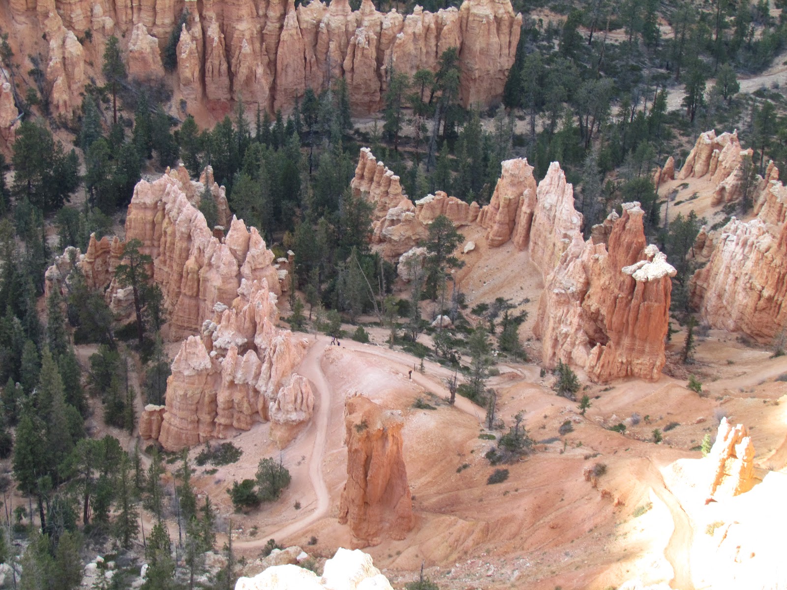
We picked up a few virtual geocaches along the way. We also visited the information center and found that they had an incentive program for people to hike the hoodoos. Bob and I were up for the challenge! To receive a prize, you had to hike 3 miles and find 2 benchmarks the park had put on signs along the trails. If you look closely, you can see the trail among the hoodoos in this picture.
 These are grottoes at Bryce Point. It looks like they could eventually be arches, but maybe they will erode into spires and hoodoos.
Saturday we decided to hike Wall Street portion of Navajo Loop and then connect with Queen's Garden to complete the trip back to the rim. This hike would give us two benchmarks toward 'I Hiked the Hoodoos' program and a 2.9 mile hike. This hike would also be at elevation greater than we are accustomed to when hiking.

The views as you travel down from the rim on Navajo Loop were fantastic! We wound down through the hoodoos and rock walls.

We finally reached the canyon floor and looked up to see the rim--what a sight! It is amazing how the trees were able to grow on the canyon floor--straight and tall--reaching for the light near the top of the canyon!
The remainder of the loop we followed was tree lined--we didn't expect that from what we could see from the rim before we started our hike.
It wasn't long before we found our first sign with a benchmark.
 We continued on to Queen's Garden trail. Trails in the southeastern U.S. are marked with color blazes on trees. Here in the southwest, trails are marked with rock cairns. At Queen's Garden, everyone contributes a rock cairn to the 'garden.' They look like miniature hoodoos.
Then it was on to Queen Victoria's hoodoo. There was a benchmark located below Queen Victoria--she is the hoodoo directly above the sign.
After finding Queen Victoria, it time to hike back to the rim. The Queen's Garden trail had a much gentler slope. It also had some interesting features to hike.
After completing the trail it was time to head back to the rv for lunch and a rest before exploring more of the park.

Later in the afternoon we decided to drive out of the park to Mossy Cave. It is part of the park, but located on UT 12 northeast of the main park. There is a trail to Mossy Cave which follows Tropic Ditch. The canal took 2 years to build, but it brought irrigation water to the Mormons who had settled the area.
We found the benchmark at the fork in the trail.
The right fork led to the waterfall for Tropic Ditch.
The left fork led to Mossy Cave. As you stand near the rock overhang, you can hear the water dripping from a spring somewhere above. We looked carefully trying to see where it was coming through and found that is was dripping down through every rock!
This was our last day at Bryce. Bob had been watching the weather and knew we wanted to get to Kanab to try to register for the lottery to hike 'The Wave.' The lottery is held every morning at 9 a.m. at the BLM office in Kanab. If you win the lottery you may hike the next day. Only 10 people win the lottery a day. We'll see what happens.

Saturday, October 13, 2012

Moab, Utah and Beyond

Wednesday morning we had to pack our things and say goodbye to the fantastic campsite we had at Arches National Park. We were still going to be in the area (Moab), just not at the national park. Earlier in the week we checked out a Passport America campground in Moab since we knew we needed a few more days in the area so our mail could catch up with us. Bob found the OK RV Park just south of Moab and it had a spot for us! The excitement is because there was a Gem and Mineral Show starting on the weekend and we weren't sure any parks would have openings.

After moving to the new site (sorry, no pic, but check the coordinates at the right), we took it easy as we were having dinner with some Escapee Boomers I contacted on-line. At 4:30, we met Dona and Joe at Moab Brewery. When we arrived and were seated, the place was empty, but much later when we decided it was time to leave, there were many people waiting for seats---OOPS! But we had a great time talking with Dona and Joe. We hope to see them down the road someday.

Thursday we wanted to drive the LaSal Mountain Loop. It is a scenic drive through, you guessed it, the LaSal Mountains. Well, as we were getting in the car a man from the rv park asked where we were going, told him, and he said that the top of the drive is closed for road construction. He recommended that we go north on the scenic drive by the Colorado River, turn onto the LaSal Loop at Castle Rock and we might see more than if we start at the south end of the loop. So, we did. Now, of course, most of you know that we don't drive anywhere without geocaching. Yes, that was also on the agenda.

One of the caches was at an old cattle corral on the LaSal Loop. The hint indicated that it was near an old truck. Well, here is the truck and yes, it is definitely old!

We saw some leaves changing, but not many. Mostly cottonwoods turning yellow near the river.
We went as far as we could on the loop before the road was closed (not as far as we had hoped) and then we turned around and headed back to the winery on the Colorado River! Bob and I each tasted three wines, then we purchased a bottle of Kid Red.

Our next stop was lunch at the best rated place to eat in Moab--Quesadilla Mobilla. It was definitely a good spot to get our lunch. We agree with the people who rated it the best. I had a quesadilla with spinach, chicken, and artichokes. Bob had the Fiery Fungus with beef, mushrooms, and jalapenos. Yum!

Then it was time to shop for some long-sleeved shirts for Bob. When you're packing in Florida and the temperatures are close to 100 and the humidity matches, it's hard to think of packing clothes for cool weather. And that is what happened! Bob didn't pack any of his cold-weather shirts. Thank goodness I packed the windbreakers, hoodies, and jackets!

Bob and I both found shirts and it was time to head back to the rv. We needed to do some laundry as we have no idea when we will be close to laundromats again. Before doing laundry, we checked the post office for our mail and it wasn't in yet. We would try again Friday morning.


Then it was back to the rv to watch the debates--we had cable!

When we awoke Friday morning it sounded like growling outside the rv. No, it couldn't be--it was thunder and then we heard the raindrops hitting the roof. It is not supposed to rain in the desert! It looked like it would hang over Moab the entire day.

Before checking out of the park, we went downtown to do some last minute grocery shopping and to check the mail. We got everything on our list, found out there are two, not one, grocery stores in Moab, got our mail (yea) and went back to the rv to head to Goblin Valley State Park (Galaxy Quest was filmed in this park). We were wondering how the rain would affect the desert.

It started to clear up as we left Moab. The drive to Goblin Valley was uneventful. When we arrived, we were disappointed that all the sites were filled. Many of the trails were closed due to the wet conditions so we continued on our way to Capitol Reef National Park--one of our many favorites. Our biggest hope was that there would be a camp site available when we arrived.


The rain had turned the Fremont River which was just a trickle our last visit in this area into a raging, red river! In addition to seeing a raging river in the desert, there were waterfalls coming down the rocks near Capitol Reef! It was an amazing sight. You expect to see waterfalls when you drive through the Smokey Mountains, not when you drive through the desert! The waterfalls were not clean, clear water, but red from all the red sandstone that the water was washing away!

 Finally, we arrived at Capitol Reef! It was soaking wet, but we got one of the last two campsites! Since our last visit, the sites have been paved!
The area was much too wet to even consider hiking, so we only stayed one night.Saturday morning we enjoyed a quick walk around the campground, watched the horses near our site, then packed the rv to leave.
  We wanted to move to someplace drier where we could hopefully get back to hiking--Bryce Canyon National Park, here we come!

Thursday, October 11, 2012

Last Day at Arches National Park


Bob and I decided to give the difficult primitive trail to Double O Arch a try. We also needed to see the two arches that were north of the trail that we passed on Monday. It was a little warmer on Tuesday, but we still needed our jackets for the first part of the trail as it is in the shade and the wind whistles between the rocks early in the day.

We started the trail and made the detour to Tunnel Arch. This one was interesting because there was the large arch and a much smaller arch to the left.
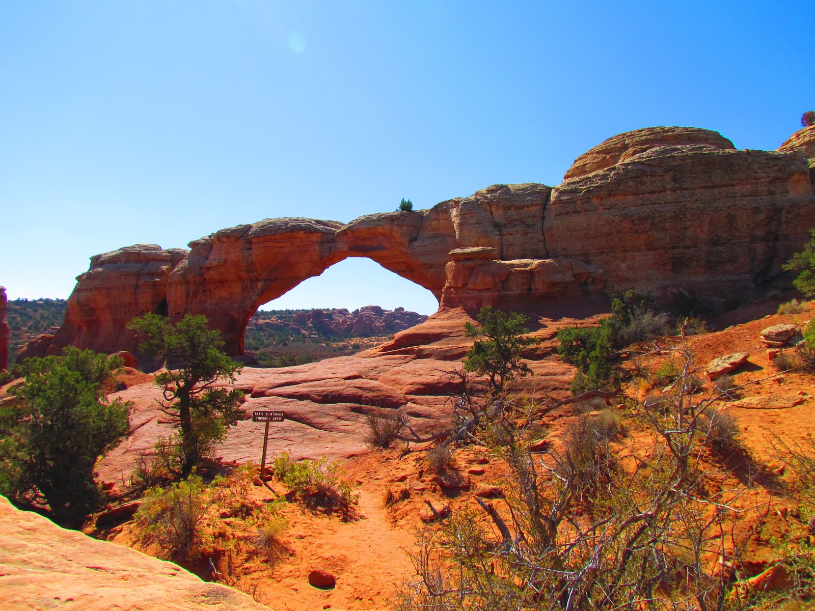
Pine Tree Arch was next and we think it got its name because of the pine tree growing beneath it.
Then it was on to the primitive trail. It started just beyond Landscape Arch. The beginning of the trail had that wonderful deep red sand. Most of the trail went up and down for the first mile or so.
We couldn't figure out why the trail was marked difficult. Then at  two miles out, we found out why. We came to a slickrock wall that required a step up of about 3 1/2 feet. I couldn't make it up. Bob went up and around the ledge and said it looked a little hairy so I cried 'Uncle' and we started the hike back to the trailhead. We figured we made it about 3/4 of the way to Double O Arch.

Since it was our last day at Arches, we started packing to make Wednesday an easy travel day. We weren't going far, just to Moab and the OK RV Park. Time to wait for mail!

MOUSE UPDATE: WHILE AT ARCHES WE CAUGHT TWO OF THE CRITTERS IN THE STICKY TRAPS WE ALWAYS CARRY. OUR MUNCHIES AND BREAD ARE NOW IN HARD PLASTIC CONTAINERS. TAKE THAT YOU CRITTERS!

Arches National Park: The Hike to Dark Angel

Monday arrived bright and cold! Another morning in the low 40's. Bob and I donned our hiking gear and jackets and set out for the trail to Dark Angel. The first part of the trail is popular with tourists and the parking area fills quickly every day. We wanted to get ahead of the crowd and we managed to do just that. The hike would be a little over 6 miles round trip.

Our first stop was Landscape Arch. It is a little over a mile from the trailhead and most tourists make it this far, but not much farther as the trail becomes more difficult. Of course, we got credit for a geocache by taking a picture at the arch.
The next part of the trail involved walking up slickrock. To get on the slickrock there is a huge step. I made it up, and I knew that to get back down on the return trip that I would sit and slide to get off the rock!
 
 We arrived at the junction for Partition Arch and Navajo Arch, but decided to see those two after we hiked to Dark Angel which is about .4 of a mile beyond Double O Arch.
 Of course there was another section of slickrock which just happened to be the top of a fin! After making it to the top of the fin, I decided if I went down, I would go to my left as that drop was only about 30 feet and the drop to my right was about 5 times that distance!

 Once over the fin, it was a short hike to Double O Arch. And yes, we got a geocache for hiking to Double O. The area below the arch also had that deep red sand that is like walking in deep beach sand.
 This is a picture of the back of Double O Arch as we headed to Dark Angel.
 Dark Angel is a tall, dark spire at the end of Devil's Garden. It is also the end of the trail. We stopped for a rest and a snack before we headed back to see the arches we skipped on hike to Dark Angel.
 We made it back to the junction and yes, I did the slide down the slickrock in all the appropriate places.
 The first arch on the return trip was Partition Arch. It gave a great panoramic view of the valley below.
Navajo Arch was the last arch on our trail. It seemed much thicker that the other arches we have seen.
Just before you get to Navajo there is a wall with many holes that have eroded. It amazes us how round the holes are and how they are all in one section of the wall. We stopped for pictures on the way back.
We enjoyed the hike, but were curious about the primitive trail that loops north of the trail we took to Double O Arch. Hmmmm, maybe it will be our next hike.

Wednesday, October 10, 2012

Arches National Park: The Campground Trail

Sunday we decided to walk the trail from the campground. It goes by three arches. Most people don't walk to the arch closest to the campground, Tapestry Arch. This arch is only about 400 yards from the trailhead that starts at camp site 39.

I have to say we were glad to stay close to the campground as it was a chilly day. When we awoke it was in the low 40's in the rv! Yes, we turned on the heat to take the chill off, but as we were warm and cozy, we looked out the windows at all the tent campers who wished they were warm and cozy!

From Tapestry Arch we hiked to Broken Arch. We believe it got its name because of the crack in the top of the arch. The trail continued through the arch and across a grassland to Sand Dune Arch.
Sand Dune Arch was one of the most interesting arches so far. Once you got across the grassy area, you walked between fins and rock overhangs to get to the arch.
The 'floor' near the arch was covered in what looked liked reddish orange beach sand, but the sand was very fine and deep. It had eroded off the sandstone which make the arches.
Bob and I enjoyed exploring the area under the arch and rock overhangs.
Then it was time to head back to the campground and our rv. We were able to cross the grassland and take a different path back to the campground. And yes, it finally warmed up enough for us to take off our jackets.
 This is a zoom view of our rv from the trail.
We relaxed at the rv for the rest of the day. Monday was going to be our longest hike yet: Devil's Garden to Dark Angel.

Tuesday, October 9, 2012

Arches National Park: The Drive and Overlooks

Saturday the weather turned cooler and we didn't want to do any of the major hikes on the weekend when the park was even more crowded, so we drove the scenic drive and headed into Moab for those supplies.

Our first stop was Fiery Furnace. It was the one place we couldn't hike. The hikes into the 'Furnace' are ranger led and are booked on-line months in advance. We didn't know that when we made our campground reservation or maybe we could've gotten on the list!

 Our next stop was Salt Wash Valley Overlook.
From there it was on to Panorama Point.

 After Panorama Point, we headed for The Windows. We knew there would be a lot of people as this is on the tour buses schedules. First we saw Double Arch.

 Then we went across the parking area to Turret Arch,
turned around and saw The Windows.
Most people stayed on the paved trails in front of The Windows, but Bob and I decided to hike behind where the tourists don't have time to go as they have to get back on their buses.
 Moab was our next stop. We need to find the grocery store and a place to buy our plastic containers to mouse proof the food in the rv. I  have to say it was a successful trip. We found the one grocery store in Moab and an ALCO (similar to Big Lots). On returning to the rv we placed all the goodies in the two storage containers we purchased and chilled out for the rest of the day.

Sunday was to be another cold day, but we planned to hike to the arches near the campground.