Bob and I visited Bryce Canyon back in 2008, but all we were able to do was drive and look at the viewpoints. The weather was windy and cold, and the trails around the hoodoos were covered in snow. This trip was much better. This time we brought the rv and camped at North Campground inside the park. The temperatures during the days were in the mid 60's. At night, however, the temperatures dropped into the upper 20's--BRRRRR!
Our first day at Bryce, Friday, we did the scenic drive and checked out all the sights. It always amazes me to see the different rock formations so near each other in Utah.
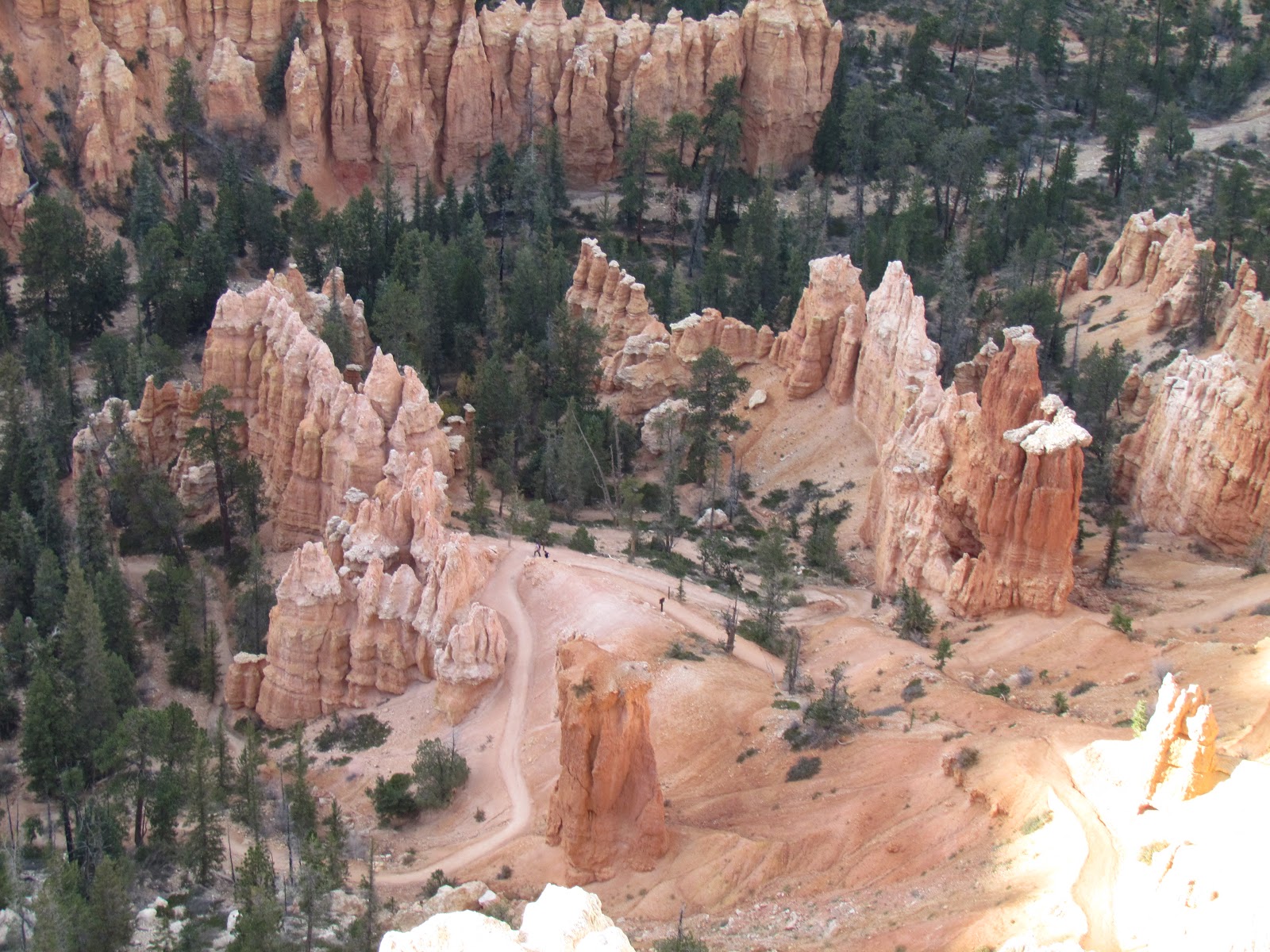
We picked up a few virtual geocaches along the way. We also visited the information center and found that they had an incentive program for people to hike the hoodoos. Bob and I were up for the challenge! To receive a prize, you had to hike 3 miles and find 2 benchmarks the park had put on signs along the trails. If you look closely, you can see the trail among the hoodoos in this picture.
These are grottoes at Bryce Point. It looks like they could eventually be arches, but maybe they will erode into spires and hoodoos.
Saturday we decided to hike Wall Street portion of Navajo Loop and then connect with Queen's Garden to complete the trip back to the rim. This hike would give us two benchmarks toward 'I Hiked the Hoodoos' program and a 2.9 mile hike. This hike would also be at elevation greater than we are accustomed to when hiking.
The views as you travel down from the rim on Navajo Loop were fantastic! We wound down through the hoodoos and rock walls.
We finally reached the canyon floor and looked up to see the rim--what a sight! It is amazing how the trees were able to grow on the canyon floor--straight and tall--reaching for the light near the top of the canyon!
The remainder of the loop we followed was tree lined--we didn't expect that from what we could see from the rim before we started our hike.
It wasn't long before we found our first sign with a benchmark.
We continued on to Queen's Garden trail. Trails in the southeastern U.S. are marked with color blazes on trees. Here in the southwest, trails are marked with rock cairns. At Queen's Garden, everyone contributes a rock cairn to the 'garden.' They look like miniature hoodoos.
Then it was on to Queen Victoria's hoodoo. There was a benchmark located below Queen Victoria--she is the hoodoo directly above the sign.
After finding Queen Victoria, it time to hike back to the rim. The Queen's Garden trail had a much gentler slope. It also had some interesting features to hike.
After completing the trail it was time to head back to the rv for lunch and a rest before exploring more of the park.
Later in the afternoon we decided to drive out of the park to Mossy Cave. It is part of the park, but located on UT 12 northeast of the main park. There is a trail to Mossy Cave which follows Tropic Ditch. The canal took 2 years to build, but it brought irrigation water to the Mormons who had settled the area.
We found the benchmark at the fork in the trail.
The right fork led to the waterfall for Tropic Ditch.
The left fork led to Mossy Cave. As you stand near the rock overhang, you can hear the water dripping from a spring somewhere above. We looked carefully trying to see where it was coming through and found that is was dripping down through every rock!
This was our last day at Bryce. Bob had been watching the weather and knew we wanted to get to Kanab to try to register for the lottery to hike 'The Wave.' The lottery is held every morning at 9 a.m. at the BLM office in Kanab. If you win the lottery you may hike the next day. Only 10 people win the lottery a day. We'll see what happens.


1 comment:
So glad you both made it through that hike without having to cut one of your arms off...it looks like the scene from 127hrs:) -Love ya! Jen
Post a Comment