Well, we left the casino and headed further into Washington. We stopped at Lake Quinault to get information from the ranger station. It was a combination station with information about Olympic National Forest and Olympic National Park. The ranger recommended we drive around Lake Quinault to see the waterfalls and walk some short trails. We thought that was a good idea so we unhooked the car, left the rv parked at the ranger station and drove the 20+ miles around the lake.
The area is part of the Quinault Rainforest. We enjoyed the drive and stopped to view the waterfalls. The first one was taller than the second. If we hadn't had the map from the ranger, we would have missed this one!
The area is part of the Quinault Rainforest. We enjoyed the drive and stopped to view the waterfalls. The first one was taller than the second. If we hadn't had the map from the ranger, we would have missed this one!

Not only was the top gorgeous, so was the bottom!
 We left the first after a short photo session and drove to find the second falls. It didn't have the straight fall like the first, but it was still beautiful.
 Right before we saw the second waterfall we found a sign for Olympic National Park.
 As we continued around the lake we found out why we needed to unhook the car--the road narrowed to one lane and was gravel for about 6 miles on the north side of the lake.
We left the first after a short photo session and drove to find the second falls. It didn't have the straight fall like the first, but it was still beautiful. Right before we saw the second waterfall we found a sign for Olympic National Park.As we continued around the lake we found out why we needed to unhook the car--the road narrowed to one lane and was gravel for about 6 miles on the north side of the lake.  Also on the north side of the lake was another ranger station. We stopped and walked the trails at this station. One led to an old homestead which the park hopes to redo.
 The homestead was sold to the park in the 5os. There is a sliding glass door and ugly shag carpet. In the field next to the barn was an old moving van which probably won't make any more moves.
 The other led through to the Mossy Trail. In this portion of the rain forest, club moss grows on the big maples. The moss grows everywhere on the trees and it hangs down like drapes from the limbs. When it is first growing it is a bright green, but as it ages it turns a yellowish green.
 True to the rainforest, the tree was supporting other life as well.
 From the lake drive we returned to the first ranger station and walked next door to Quinault Lodge. It was built in the early 1900s. The first lodge burned and was soon rebuilt.
 There was a newspaper clipping showing the lodge in its early days.
 This is the back lawn today.
 This ornate ruler measures the water when it overflows the banks of the lake.
 After touring the lodge we hooked the car back to the rv and headed for South Beach Campground in Olympic National Park. We had our first sunset in quite a while--it was not big and it was too chilly to go out for a toast!


 These birds flew around us trying to find a new spot to walk the beach.


 And then we saw an

 From there we proceeded along the promenade viewing the sights and collecting clues for to solve the geocache. Astoria was built in 1822 over the water. Everything was built on pilings as they thought the land to steep a place to build. Also, it was easier to offload ships when the canneries were on the water. Many old canneries have disappeared, but the pilings remain.
 The mural on the back of this Sear's was also a clue. Many of the buildings had murals depicting Astoria in the past.
 Another geocache was located on the anchor outside the Maritime Museum.
 We toured the museum and recommend it to anyone traveling this way. It has history of the Columbia River, Coast Guard, Navy, Astoria, etc. The pilot house of a navy ship was donated to the museum before it opened. The pilot house was floated to the museum by means of a barge and place by crane on the area where the museum would be. The museum was built around the 13 ton pilot house.
 From the Maritime Museum we continued our geocaching and searched for a place to have lunch. As we completed the geocache puzzle and found the last cache we spotted a familiar name--Rogue. This Rogue is a public house--we've already eaten at their brewery (South Beach).
 The Rogue Public House is located in what used to be the BumbleBee cannery. The cannery has been rebuilt and now houses people, businesses, and the public house. We walked across the wooden bridge to get to Rogue.
 We went in and had a pleasant lunch.
 We planned our next stops while eating. A trolley runs the length of the promenade so we decided to ride the Trolley back to our car.
  There was also a cache hidden on the Trolley!
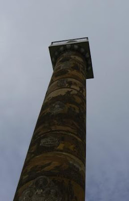 The column sits upon Coxcomb Hill--one of the highest spots in Astoria. There is a spiral staircase that you can walk to the top to view the surrounding area--unfortunately the column is closed until next spring or until the new staircase arrives and is installed! The view from the surrounding area is still great!


 At the base of the cliff where we viewed Tilly, there were rocks in the surf. The white on all the rocks is from the birds. They love to nest on the rocks in the area.

 The original fort is long gone and the first replica built in 1955 from the journals of Lewis and Clark burned in 2002. This replica stands as close to the original as could be deciphered from the journals. The open door was the room of the Charbonneau family (Sacajawea, etc.)
 Lewis and Clark shared this room which was next to the Charbonneau's.
 After the demonstration we joined a ranger hike to Netul Landing. It was a nice hike through the trees whose cover was thick enough to keep the rain from getting us.
 The ranger pointed out many interesting plants and told their uses. This is a giant horsetail. The texture of the leaves made it good for scouring pans and such. You can see the 'ribs' along each leaf that give it its texture.
 From Fort Clatsop we drove south to Seaside, Oregon. It is a beach town with all the appropriate beach shops, arcades, and a promenade (boardwalk along the beach). We found a place to eat lunch and stay out of the rain. We are still sampling the fish & chips of each area.

 It also saw duty in WW II and was shelled by a Japanese submarine. Soldiers in the fort did not return fire as the submarine was out of range. This is one of the batteries that protected the coast.
 We thought this deer was guarding one of the old buildings...
 ...she was actually resting as her fawns played in the nearby bushes.
 When we returned to the rv we had lunch, then set out on our bicycles to find the caches on the bike trails. One cache was located near the beach and the wreck of the ship Peter Iredale.