Thursday, September 30, 2010
The Badlands--Sept. 24-25, 2010
It was just a short trip from Ellsworth to the Badlands so we made a side trip to Wall Drug in Wall, SD.
From there is was on to Badlands National Park.
Not far from the entrance we saw big horn sheep.
The landscape in the park reminded us of Theodore Roosevelt NP, but the layers are different.
Our first night we had a beautiful sunset.
Saturday morning we walked Fossil Trail for an earth cache.
Then we hiked Saddle Pass Trail to get to Castle and Medicine Root Trails.
We had to go over the hills to get to the trail in the grassland.
There was a great view from the top of Saddle Pass Trail.
This sign marked the halfway point of our loop.
Of course there was a sign announcing the possible presence of my least favorite critter.
The camp sites at Badlands were mostly small pullouts, but they were great for solar!
We enjoyed our stay at Badlands National Park, but it seemed like time was running out on this trip! We want to be home to vote and we still have people to see and things to do!
Sunday, September 26, 2010
On to South Dakota--Sept. 18-23, 2010
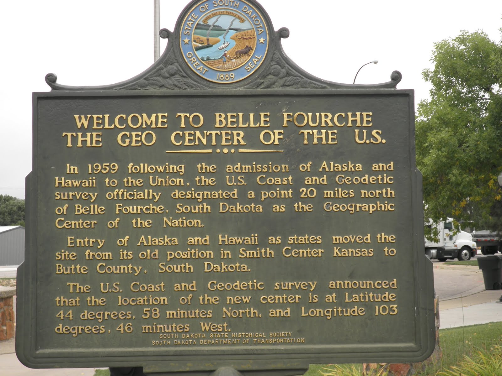
As the snow melted at Theodore Roosevelt NP, we started our journey to South Dakota. We originally thought we would head to Ellsworth, AFB in Rapid City, but when we reached Belle Fourche--the geographical center of the U.S. we changed our minds.
We stopped at Belle Fourche and toured the museum in the Chamber of Commerce. We also walked around the monument. Flags from all 50 states fly around the compass rose.
From Belle Fourche we headed to Custer, SD. We thought Custer would be a better vantage point for touring the area. We stayed at a Passport America Park--Broken Arrow Horse Campground.
Since we arrived late in the afternoon, we started touring early the next morning. Our first stop was Custer Skywalk
to find a geocache located along the trail.
At the halfway point was an overlook for the town of Custer.
From Custer we headed west to Jewel Cave. We stopped there 2 years ago, but missed the cave tour by a few minutes. This time we made it for the scenic tour. There were 743 steps in the 1/2 mile tour. It was an interesting cave, but Bob and I both like caves with more varied formations.
We walked around Hill City and visited the shops which were open. I have seen so many tourist shops that I am all shopped out--nothing varies except the names on the souvenirs! We also found some geocaches in town.
To get back to our campground, we drove part of the Norbeck Scenic Byway. The byway has some very narrow tunnels.
From the Norbeck Overlook we could see 'The Heads.'
The next day we went to Custer State Park to find the caches hidden in the park. Our first stop was Lake Bismark just inside the west entrance. We had a great hike up and down the rocks in the area.
Mt. Coolidge is located in the park and there was a geocache hidden among the rocks at the base of the building.
We had a great view from Mt. Coolidge!
Another day we drove the wildlife loop in Custer. We saw most of the animals advertised--buffalo,
coyotes, turkeys, pronghorn antelope,
deer (white-tail and mule), and burros.
From the wildlife loop we drove south to Wind Cave. Most of the buffalo herd from Custer was located at Wind Cave the day we drove through. We stopped at the visitor center, but did not tour the cave.
We enjoyed the hiking in the area. The day we were going to go to 'The Heads,' we stopped to hike a trail in Black Hills National Forest and Norbeck Wildlife Preserve.
There were 3 geocaches along the trail, but we could only find 2. The one we couldn't find was above this waterfall.
The evening before we left the area, we drove the wildlife loop again. This time we saw more burros and people feeding them!
When we left Custer and Broken Arrow Campground, we headed to Ellsworth AFB outside of Rapid City. It was time to do laundry, visit the commissary, and get new tires for the front of the rv. With all the rough roads we have driven, the front tires were wearing in a funny pattern and the front end needed an alignment.
Friday morning we packed the rv and headed to the tire place for our new tires. That took about 45 minutes then it was on to the place where we could get the front end aligned. We finally left Rapid City about 1 o'clock. Next stop---THE BADLANDS!
To get back to our campground, we drove part of the Norbeck Scenic Byway. The byway has some very narrow tunnels.
We enjoyed the hiking in the area. The day we were going to go to 'The Heads,' we stopped to hike a trail in Black Hills National Forest and Norbeck Wildlife Preserve.
Friday morning we packed the rv and headed to the tire place for our new tires. That took about 45 minutes then it was on to the place where we could get the front end aligned. We finally left Rapid City about 1 o'clock. Next stop---THE BADLANDS!
Tuesday, September 21, 2010
Theodore Roosevelt NP South Unit--Sept. 14 to 18, 2010
From Theodore Roosevelt NP North Unit we took the long way to South Unit. It would have been 68 miles driving south on US 85, but the road construction reminded us of Alaska and we didn't want any part of a long gravel road for our drive. We headed north and then west to 16 to head south. It doubled our miles, but it was a relaxing trip with no road construction!
The weather was great for our drive and when we arrived at the South Unit. We drove to the campground 5 miles into the park, found a site and ate our lunch. Our next activity was to go back to the entrance to tour the visitor center and to drive around the town of Medora.Later that evening we drove the scenic loop and saw some animals as well as great views.
One thing South Unit has is feral horses. These are the descendants of horses that escaped from ranches long ago. They now reside at the national park.
Of course there were lots of deer.
We drove to one of the overlooks and had a great view in all directions
once we climbed the steps.
Our first full day in Medora, we decided to geocache our way to Dickinson. That was where the closest Wal-Mart was located. We needed a few supplies and there was no grocery store in any of the closer towns!
On the Thursday we chose to hike to Petrified Forest. It is located in a remote region of the park. We accessed it by driving out of the park through ranch and oil land to the trail head closest to the forest. It would have been an 11 mile hike if we hadn't! It was 4 mile round trip hike by going outside the park!
It was a great hike and we had some warm weather--temps in the lower 70s!
The area was filled with petrified wood,
bentonite (the grey ground and stuff holding the rocks), and capstones.
Friday we planned to hike the Burning Coal Vein Trail, but the weather had different plans for us. When we woke up it was raining and had already hit the high for the day--48 degrees! What happened to our sunny weather?????
We drove into Medora and looked through the shops that were open--some were closed for the season. Then we returned to the rv to get warm and dry. About 3 o'clock the snow started. That's right, snow! It snowed until 6:30 pm and then it stopped! This was the view from our rv.
The road looked clear so we took the car and drove the loop again. What a different perspective with snow!
The feral horses weren't bothered by the snow.
Neither were the deer.
Neither was this buffalo!
The views were great--snow and twilight.
Saturday morning the snow had started melting so we packed up and headed toward Mt. Rushmore.
We weren't sure where we would stay--maybe Ellsworth AFB, maybe a local campground. Only we know for sure!
The weather was great for our drive and when we arrived at the South Unit. We drove to the campground 5 miles into the park, found a site and ate our lunch. Our next activity was to go back to the entrance to tour the visitor center and to drive around the town of Medora.Later that evening we drove the scenic loop and saw some animals as well as great views.
One thing South Unit has is feral horses. These are the descendants of horses that escaped from ranches long ago. They now reside at the national park.
On the Thursday we chose to hike to Petrified Forest. It is located in a remote region of the park. We accessed it by driving out of the park through ranch and oil land to the trail head closest to the forest. It would have been an 11 mile hike if we hadn't! It was 4 mile round trip hike by going outside the park!
The area was filled with petrified wood,
We drove into Medora and looked through the shops that were open--some were closed for the season. Then we returned to the rv to get warm and dry. About 3 o'clock the snow started. That's right, snow! It snowed until 6:30 pm and then it stopped! This was the view from our rv.
The feral horses weren't bothered by the snow.
Thursday, September 16, 2010
A Hidden Gem: Theodore Roosevelt National Park--Sept.. 10-13, 2010
Wow! Theodore Roosevelt National Park North Unit was a great surprise!
We arrived and found a nearly empty campground. One section has pull-through sites and the other section has back-in sites. We found a site that was made just for us and our solar panels!
After parking the rv, we set off on the loop drive. Part of the drive would be closed on Monday for road repair and we wanted to see as much as we could so we could plan our visit. As we drove, we stopped at the pullouts to read the signs and enjoy the views.
Riverbend Overlook still has a building built by the CCC when they worked the area in the late 1930s.
This is also the last picture taken of Bob and I with our Panasonic Lumix camera.
As we drove through the park, we saw many buffalo. Some were walking along the road.
At the end of the park drive was Oxbow Overlook.
The trailhead for Sperati Point started near the overlook. Since the road would be closed on Monday, we decided to hike to Sperati Point--2.4 miles round trip.
It was a nice hike without much change in elevation, but great views overlooking Little Missouri River.
Once we got to Sperati Point, it was picture time, but alas the wind started blowing and the tripod blew down. This time we were not so lucky--the Panasonic that we really liked literally bit the dust! And to make matters worse, the tripod also broke a leg in the fall.
We picked up all the pieces and made the hike back to the car. It was still a nice hike.
Saturday night we attended the ranger talk about Theodore Roosevelt--Bob and I were the only ones in attendance besides the ranger even though the campground almost filled! We learned a lot about Roosevelt and about becoming a full-time ranger.
Sunday we decided to hike the nature trail near the campground in the morning. Little Mo Nature Trail is wheel chair accessible for most of the way. Near one of the posts marking an interpretive area, I spotted one of my least favorite creatures--a rattlesnake--sunning himself half on and half off the trail! Bob of course went back for a picture--I had already sprinted far ahead.
Not far after the snake, we veered off the paved trail and into the badlands (still the trail).
We became familiar with the grey clay substance bentonite. All the trails are covered in it! It is a chemically changed volcanic ash which is very slippery when wet. One of the amazing things about bentonite is the many uses it has in our everyday life--auto polish, face creams, crayons, laxatives and spark plugs!
These steps lead up to an area ....
.....with a great view of Little Mo.
After returning to the rv for lunch, we decided to hike Caprock Coulee Loop Trail. This would be the first day in a long time that we hiked over 5 miles! Of course, we gathered information for a geocache along the way.
This trail wound its way through the badlands. We had terrific views in all directions.
The first part of the trail wound through trees on the cool, northern slopes of hills. The last part took us on the southern slopes which had less vegetation and were much warmer.
We returned to the rv for an enjoyable evening and even spent some time outside looking at the stars--almost no light pollution in the park!
Monday we drove back to Caprock Coulee Trailhead to hike a different trail--Prairie Dog Town. This trail set off going east of the Caprock Coulee Trail. It was a nice hike to two prairie dog towns. As we neared the first town, the prairie dogs began their high pitched yipping to warn others of intruders. They kept it up until we passed through the town. These were the plumpest prairie dogs we had ever seen!
At the end of the second town, we came to the end of the trail.
Time to turn around and head back to the rv for lunch.
Later that afternoon we walked from the campground to Cannonball Concretions which was across from the campground entrance. We walked into a canyon for some photos--without the use of our tripod. Bob found a nice flat rock to hold our other camera.
Then we walked a short portion of the Buckhorn Trail--only until we came to a steep hill of bentonite--and then we went back to the campground. Yes, this was day 2 of walking over 5 miles! It was about time we got some exercise!
We left the north unit Tuesday morning headed for the South Unit of Theodore Roosevelt National Park.
There are several things that surprised me about North Dakota--the number of oil wells and the wacky division of Mountain/Central time zones!
As we drove through the park, we saw many buffalo. Some were walking along the road.
We picked up all the pieces and made the hike back to the car. It was still a nice hike.
Saturday night we attended the ranger talk about Theodore Roosevelt--Bob and I were the only ones in attendance besides the ranger even though the campground almost filled! We learned a lot about Roosevelt and about becoming a full-time ranger.
Sunday we decided to hike the nature trail near the campground in the morning. Little Mo Nature Trail is wheel chair accessible for most of the way. Near one of the posts marking an interpretive area, I spotted one of my least favorite creatures--a rattlesnake--sunning himself half on and half off the trail! Bob of course went back for a picture--I had already sprinted far ahead.
We became familiar with the grey clay substance bentonite. All the trails are covered in it! It is a chemically changed volcanic ash which is very slippery when wet. One of the amazing things about bentonite is the many uses it has in our everyday life--auto polish, face creams, crayons, laxatives and spark plugs!
These steps lead up to an area ....
Monday we drove back to Caprock Coulee Trailhead to hike a different trail--Prairie Dog Town. This trail set off going east of the Caprock Coulee Trail. It was a nice hike to two prairie dog towns. As we neared the first town, the prairie dogs began their high pitched yipping to warn others of intruders. They kept it up until we passed through the town. These were the plumpest prairie dogs we had ever seen!
Later that afternoon we walked from the campground to Cannonball Concretions which was across from the campground entrance. We walked into a canyon for some photos--without the use of our tripod. Bob found a nice flat rock to hold our other camera.
We left the north unit Tuesday morning headed for the South Unit of Theodore Roosevelt National Park.
There are several things that surprised me about North Dakota--the number of oil wells and the wacky division of Mountain/Central time zones!
Subscribe to:
Posts (Atom)