Once inside the park, we stopped at the parking area for Faraway Ranch and unhooked the car so we could drive to the visitor center. We wanted to find out about camping in the National Forest outside the park. The person we talked to in the visitor center told us the National Forest campgrounds were very muddy and probably not a good choice for us. This person went on to tell us that the triangle of land outside the park entrance has been used frequently by big rigs and no one seems to care that they park there. Hmmm...that would be much more convenient than a muddy campground 5 miles from the entrance so that is where we parked. It turned out to be a great site!
After getting set up we wanted to go for a short hike to get acclimated to the elevation. Once again we were over 5000 feet. We drove back into the park and took the Lower Rhyolite Trail to the intersection of several other trails. It was a nice hike, going up for the first half, then descending to the visitor center again.
The views were great. We enjoyed hiking--for the 5th day in a row!
It was nice to be in forests again. As we hiked I could smell the scent of the trees! Much better than the dust of the desert.
Thursday we drove about 12 miles back toward Willcox and took the dirt road to Ft. Bowie National Historic Site. We passed this when we visited 5 years ago and this time we decided we had to make the drive and hike to see the site.
After an 8 mile drive on a relatively good dirt road we came to the parking area. From the parking area it is a 1.5 mile hike to the fort. Along the way are several historical ruins to see. This is a view of some of the ruins of the fort that we could see from Apache Springs.
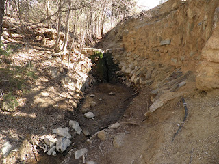
Being from Florida, we expect springs to have boils and be large areas of running water---not in Arizona. This is Apache Springs! Enlarge the picture and you may be able to see the water trickle down from the rocks!
Not far from the springs was an Apache encampment. Battles were fought over the water in the spring. Like most Apache camps, the buildings were built by the women. The men hunted and the women did all of the other chores.
As we approached the fort, we noticed that there wasn't much left of the buildings. The foundations were intact, but the wooden walls were taken or rotted years ago. What is left has been covered in a thin layer of protective cement.
It makes the ruins look strange.
While we were touring the fort, a group arrived on horseback to tour the ruins.
When we left, we took the overlook trail back to the parking area. This was one of the overlooks. The building on the left is the visitor center.
From this overlook you had the vantage point of the Apaches as they fought members of the California Column who were approaching the springs.
Friday it was time to hike Echo Canyon Loop trail. We hiked this trail when we visited the park in 2008. This time when we hiked the trail, there was no snow or ice!
From this trail you get a good view of the rocks! No wonder this park is called 'Wonderland of Rocks.'
The rocks (rhyolite) were formed from a volcanic eruption 27 million years ago. Over the years the rocks have been eroded by weather and ice.
Today, lichen is growing on many of the rocks and that, too, will cause the rocks to weaken.
There are many nooks and crannies to explore along the trail.
Trees take root where ever they find a small amount of soil.
This creek doesn't have nearly the volume of water it did 5 years ago. Then we got our feet wet trying to cross, but this time we walked right across without going near the water!
Echo Canyon Loop Trail consists of several trails linked together. The final trail on the loop is Ed Riggs Trail. It takes you from the canyon up to the parking lot at the trailhead.
After hiking this trail we returned to the RV for lunch. Later in the afternoon we decided to go for a drive and pick up a few geocaches. There weren't many in the area, so it was quite a drive! Our first stop was Cochise Stronghold in Coronado National Forest off AZ highway 191.
There were several geocaches along Cochise Trail, but because we were running out of daylight, we weren't able to grab those caches. They are hidden somewhere in these rocks!
As we drove home through Willcox, we were treated to an awesome sunset!
The next day, Saturday, we were leaving Chiricahua to get away from the cold front moving our way. Unfortunately, we didn''t get an early start due to strong winds. By the time we were ready to leave, this is what it looked like from the passenger window in the RV.
A little later on, the wind died down, the snow stopped and we made our way to Interstate 10 at Willcox and continued our journey to the east.
Bob drove all the way to Deming, New Mexico, where we stopped at the Escapee park--Dreamcatcher RV Park just off the interstate. We got a dry camping site for the night and hunkered down with the heat on high.
The next morning after dumping tanks, we were on the road once again. Our next stop was a rest area west of Caprock, New Mexico along US Highway 380.
We decided that there wasn't much we wanted to see in New Mexico. There is a portion of Texas we would like to explore (weather permitting) along the Texas/Oklahoma border. After a restful night at the rest area, we headed into Texas.
As we drove along the US Highway 380, we were able to pick up a few geocaches. One was at the New Mexico/Texas state line.
We finally stopped at Crosbyton, Texas. It is on US Highway 82 west of Lubbock. We stopped in a city park that has full hook-ups at no charge.
After we got set up we went to mail Valentine cards to Chris and DeAnna, then we explored the area. We found a few geocaches. One was at this great rest area just east of Crosbyton.
So after 73 days of no hook-ups, we once again have electric, water, and sewer! Since we have done so much traveling the last 3 days, our budget is up to $55.94 a day. It takes a lot of gas when you are driving against the wind!
And by the way, we didn't out run the cold front. It is right here with us!


