Friday, September 26, 2008

New Mexico--Again! September 19-27, 2008

Friday we drove all day--very unusual for us! At first the plan was to stop at Sugarite Canyon State Park near Raton, New Mexico. As we exited at Raton in northern New Mexico, we decided that we would not stop except for gas and we would continue south toward Las Vegas, New Mexico.


We stopped Friday and Saturday night at Storrie Lake State Park north of Las Vegas. Saturday we drove around Las Vegas, saw the old buildings, and geocached. One geocache took us near Montezuma castle. It was originally a railroad resort, but now is Armand Hammer United World College of the American West. There are hot springs on the grounds which made it a popular resort in its day. The campus is not open to the public so we weren't able to get any pictures. It was an interesting place.

We relaxed for the rest of the time--recovering from our drive the preceding day. The campground was the first that we had visited in New Mexico that had spaces right next to each other with no ramada (shade structure over a picnic table).

From Storrie Lake State Park we were back to our normal way of driving a short distance before stopping! We drove to Santa Rosa Lake State Park. This park was like no other in that the state of New Mexico leases the campgrounds from the Army Corps of Engineers. We chose a spot at Rocky Point Campground. Usually we would dry camp, but the weather was actually warm and we wanted to run the AC.

The clouds rolled in and we experienced and afternoon thunderstorm. After the storm, there was a double rainbow! The first one is easy to see, the second one is to the right of the first and much fainter.

Santa Rosa is famous for its sinkhole lakes. One is called The Blue Hole and people come from all over to scuba dive in it. The water was a clear blue and we could see far into the hole.
Someone even put decorative fish in the hole!
From Santa Rosa, we drove to Ft. Sumner to visit the real authentic grave of Billy the Kid. It seems he is as duplicitous in death as he was in life. There are at 2 different places that advertise having his grave!We enjoyed our stay in Santa Rose. We even ate at one of their Route 66 restaurants. One thing we noticed about the small town---there were enough motel rooms to house the entire town!

Wednesday we left Santa Rosa Lake State Park and headed south to Alamogordo, New Mexico. We stayed at Oliver Lee Memorial State Park when we passed through last spring. This time we opted to stay at Holloman Air Force Base. Alamogordo is less than 60 miles from El Paso.

After arriving on base, we checked into the Fam-Camp. Our first stop was the commissary since we needed to stock the refrigerator again. It was also time to do laundry since the last time we had clean clothes was at Malmstrom AFB, Great Falls, Montana.

Friday night--tonight--Bobby and Cathy are bringing Christopher and DeAnna to stay with us for a week. We will return them to El Paso in time for the air show next weekend!

Tuesday, September 23, 2008

On the Trail: Scottsbluff, Nebraska--September 17 & 18

From Ft. Robinson we headed south toward Agate Fossil Beds National Monument. It is in the middle of no where, but interesting. There were many fossils of prehistoric mammals--no dinosaurs.
Right beside the monument sign was another sign--one that made me stay on the pavement and not get in the picture. Notice that there is no 's' on the second word! Evidently there is one snake that stays in the rocks near the sign.
We walked the mile paved trail to see fossils encased in rock. We took this picture to receive credit for a geocache. The spirals called demon corkscrews were made by prehistoric beavers.
After touring the visitor center we returned to the rv and continued on our way south. Next stop: Scottsbluff, Nebraska.
We stopped at their city park--Riverside--which is next to their zoo.
We spent the night and visited the zoo Thursday morning. Scottsbluff is a small town, and the zoo was impressive for a small town. Each section of the zoo is cared for by local families or businesses. In addition to lions, chimps, monkeys, eagles, tigers, and red pandas, there was a duck with a mohawk!
From the zoo we walked back to the rv and rode to Scotts Bluff National Monument. When people traveling the Oregon Trail saw Scotts Bluff in the distance, they knew they had completed 1/3 of their journey.
Bob didn't want to unhook the car to drive to the top so we rode in a park shuttle. The ranger gave us a running commentary all the way to the top. Once again, the CCC had a hand in building a national monument. We thanked the ranger for the ride and hiked the 1.6 miles to the bottom and back to the visitor center. If you look closely you can see the trail in this picture.
The tunnel is in the right third of the above picture. Here is the view looking south from the middle of the tunnel.
We left Scotts Bluff National Monument and headed for Colorado. It was a long, boring ride. The scenery never changed--rolling grasslands all the way! We stopped at Brush! Colorado City Park. The park has electric and water hook-ups--free the first night! And yes, there is an exclamation point after the city's name. They added it to indicate the can-do attitude of the people.
Next to the rv park was a city park with playgrounds, pool, football, baseball, and soccer fields. Across the street was a lake stocked with rainbow trout. It was a nice place to spend the night.

Friday morning we started the long drive to New Mexico. We weren't sure where we were going to stop, but we knew we would make New Mexico.

Sunday, September 21, 2008

On the Way to Nebraska--September 15 & 16, 2008

We decided to leave South Dakota and head into Nebraska. I had never been to Nebraska. Our first stop was Ft. Robinson State Park. It was originally a cavalry post, then it was sold to the Department of Agriculture and finally to the State of Nebraska. Many of the original buildings were torn down, but some remain.

This building was the headquarters building at one time. Now it is a history museum.

There as a lot of history at Ft. Robinson. It ranged from and Indian Agency to a fort to a POW camp in WWII. This is a replica of the barracks from the time of Crazy Horse.


In fact, this was where Crazy Horse was killed. Story has it that Little Big Man, native American,not a soldier, stabbed him as he tried to escape. From Ft. Robinson we drove northwest to Toadstool Geologic Area. It was out in the boonies (down a gravel road) and worth the drive. The area surrounding Toadstool was different than the buttes we saw around Crawford and Ft. Robinson. We walked the mile trail through the toadstools.
The toadstools were actually sandstone balanced on white clay. As the clay erodes, the sandstone falls. Eventually, there will just be sand as the sandstone also erodes, but at a slower pace than the clay.
We spent two nights at the state park. We also did some geocaching while we were in Nebraska. A portion of the old train tracks have been turned into a Rails to Trails area. There were several caches hidden along the trail (developed and undeveloped)!

While staying at Ft. Robinson we decided to travel south through Nebraska into Colorado.

South Dakota--September 13-15, 2008

When we left Keyhole State Park we traveled southeast on US 16 toward Custer, South Dakota.
Along the way we saw a sign for Jewel Cave National Monument. We are always ready for a good cave tour so we entered the park. It seems that September is considered the off-season and the cave tours were only available every 3 hours. Yes, we just missed the tour and there wasn't enough to see at the park to waste 3 hours so we drove on toward Custer.

We found our Corps of Engineers park near Hot Springs, South Dakota. The park was on Cold Brook Lake which is one of the small reservoirs in the area. We were the 4th camping unit in the park.We drove into Hot Springs Saturday evening and looked around. It was a nice town, the even had a grocery store named after Jennifer's dog--The Dakotamart!

Sunday we drove to Rapid City to check out the air force base and sightsee. On our return trip, we drove through Custer State Park. We thought we were supposed to see lots of different animals, but all we saw were buffalo and prong horn antelope! We had seen more than we wanted of both of those. We did eat a late lunch at the Game Lodge in Custer State Park.

When we arrived at the campground, the sheriff (who drove through often) to chat. He wanted to know how we were enjoying the area and where we were going to go Monday when the park closed! We didn't know it closed on September 15th so we had to make some quick plans.

Monday, we were on the road again! Have you figured out where we are?

Sundance and Devil's Tower--Sept. 12, 2008

Friday morning we rode into Sundance, Wyoming. The Sundance Kid was named after the town-he spent some time in the local jail before he teamed with Butch Cassidy. There was a nice museum of local history in the basement of the courthouse.
From Sundance we drove to Devil's Tower National Monument. We visited it in 1990 with Bobby and Jennifer. It hadn't changed much--you can see it for quite a distance before actually arriving at the park.
We decided to walk the trail around the base of the tower. Once again we were outnumbered by foreign tourists!
These boulders lay at the base of the tower and were once a part of the tower.
There is a column of the tower that is loose, but geologists can't predict when it will fall! People still climb that area. As we left the Devil's Tower area, we stopped to watch the prairie dogs play.
We enjoyed our stay at Keyhole State Park and made plans to move to an Army Corps of Engineers park on Saturday.

Friday, September 19, 2008

After Yellowstone--September 10 & 11, 2008

When we left Yellowstone we exited through the northeast gate at Cooke City, Montana. We drove southeast through Wyoming. There was beautiful scenery for most of the way.

We stopped for lunch at Dead Indian Campground. The sky was starting to cloud at the upper elevations, but the empty campground was a good place to picnic. After we left the campground, the clouds settled in even more. By the time we reached Dead Indian Pass, we couldn't see the surrounding area!
We continued on to Powell, Wyoming where we spent the night in the city park (free) with no hook-ups.

Our travels took us eastward through Wyoming. We investigated which route to take over the next mountains and decided on US 16. Once again, the clouds moved in as we rose in elevation. We began to wonder what was ahead of us when a snowplow passed! He was checking to see if there was accumulation! Thankfully, there wasn't any, but the snow made a good picture. (If you remember, we drove through Wyoming in May and it snowed!)
We finally cleared Powder River Pass which was about 1000 feet higher than Dead Indian Pass.
As we descended into the valley it was time to think about a place to stay. After filling the rv in Gillette we continued a bit further to Keyhole State Park.

The park was located on a large reservoir. It would make a good base for exploring northeast Wyoming. We planned to stay 2 nights. Pronghorn antelope were everywhere in Wyoming.

Where Are We?

Some of you have called and wondered what we were doing. Well, we stayed at Yellowstone National Park for a week and had a great time. We camped at Mammoth and drove to all areas of the park. Here are some of the sights we saw.

We entered through the original gate at Gardiner, MT.
Yes, we made it halfway to the north pole!
We walked the trail around Mammoth Hot Springs and viewed all the terraces. This spring changed direction about 3 years ago and blocked the trail going to the top. The minerals in the springs seeped into the trees and hardened the root and sap system, but the trees are still standing.

We drove to Roosevelt to check out the lodge, but it was closed. We stopped at Undine Falls,...

Tower Fall....
and Wraith Falls.
We visited Norris where there are two geyser basins and walked both geyser trails. The blue of the geyser pools was amazing.
It was hard to believe that the color in the geyser run-off were living organisms--thermophiles--that thrive in the hot water.
On our way back to our campsite we saw this coyote well camouflaged by the tall grass.
The elk were out in large numbers in the Mammoth area. Every day we saw bull elks sitting in the grass near the visitor center. The harem was not far away.

We started hiking Rescue Trail, but the weather wasn't looking good, so we turned back. Bob found this antler along the way.

We also stopped at Boiling River which was not on any of the handouts we were given. We would have dressed appropriately if we had known! There were quite a few people soaking in the hot water where Boiling River joined Gardiner River.
We also drove to Old Faithful with the intent of eating lunch at the Inn, but it closed about 10 minutes before we arrived. We ended up eating lunch in the Bear Pit (lounge). They only served 3 types of sandwiches, but it was good.

We also toured Canyon and saw Artists Point, the grand canyon of Yellowstone. This was the fall we could see from Artists Point.
We hiked several trails that were over 5 miles. This is one of the beaver ponds on the Beaver Ponds Trail at Mammoth.
We saw a prong horn antelope while hiking Beaver Ponds.
We also had a great view of Mammoth from the trail.
We hiked to Fairy Falls and beyond to Imperial Geyser.

Fairy Falls was interesting because not all of the water came from the top, a lot of it seeped through the rock and came out at different levels.
To get a geocache, we had to take our picture at Fairy Falls.

Imperial Geyser erupts constantly. Every now and then it settles for about 10 seconds then really shoots up.On our way to Imperial Geyser and back to Fairy Falls, we were able to get up close and personal with a buffalo who wanted to walk the trail!On our return to Mammoth, we stopped at Artists Paint Pots.
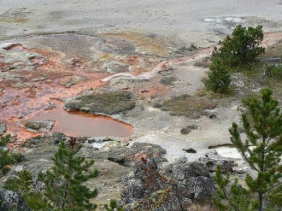
We enjoyed watching and hearing the mud plop!
We had a great time at Yellowstone and this was just a brief summary of everything we did. After we left Yellowstone through the northeast entrance, we headed toward eastern Wyoming.