Thursday, August 30, 2007

August 30th

We are sitting at Krystal using their WIFI to post the blog for 27-30 August. It turns out that all Krystals have free WIFI.


Thursday we hiked the Waterfall Trail. To get to the waterfalls, you have to hike down 584 steps along the trail. The steps are a recent addition due to erosion of the canyon walls.


These steps lead to the first waterfall.

This is a rest area under a huge rock outcropping.


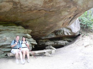
Northwest Georgia is having a drought. During a season with normal rainfall, there would be a waterfall cascading over the top of the rocks. During our trip, it was just a drip.

This is another view of where the waterfall should be!


After walking down more steps, we arrived at the overlook for the second waterfall. Notice the discoloration of the rock at the top. That is where the water was trickling over the side.


From here it was time to walk back up all the steps! We were glad that there were resting areas along the way. We stopped and saw the areas of the West Rim Trail where we had previously hiked.

We left the waterfall area and went to the wildlife viewing area which was near the disc golf course.

The only wildlife we saw was a moth on some purple wildflowers.

August 29th

Wednesday we hiked the West Rim Trail. It is a 4.8 mile trail. We left the campground on a connecting trail which made our trip 5.5 miles. It was a moderately difficult hike that we will do one more time before we leave.


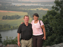
The views were outstanding. This is a view of the overlook where we were yesterday.


As you can see, some of the trees have strange growth patterns.


This a view of Trenton, Georgia.


The east rim overlook is in the background.


This is part of the trail. Most of the trail is compressed dirt and leaves, but some is rock.


Here we are at another overlook with the east rim in the background.


There were many wildflowers on the trail.


Bob found this lizard sunning on a rock.

We enjoyed our hike and did not find it very difficult. One thing we noticed was the number of pine trees with the southern pine borer. At Cumberland Falls, most of the pine trees have already been destroyed. Here at Cloudland there are still some pines standing, but many are diseased.

There are only 4 campsites occupied today—that includes us!


August 28

Wednesday brought another hot day. Even in the mountains it is in the mid 90s. We drove around the park to find the trailheads and to view the sights at the overlooks. This is one of the larger (3485 acres) Georgia state parks we have visited.

The rock outcroppings at the top left have railings where the West Rim Trail passes. We will hike there tomorrow.


This is a view of the Overlook Trail.


Once again, the railings of the West Rim Trail are on the upper rock outcroppings.

We also made a run down the mountain for supplies that should last until we leave.

August 27--Travel Day

Monday was a travel day. We are getting into retirement mode as we didn’t pull out of the campground until almost 10 a.m. We headed for Cloudland Canyon State Park in northwest Georgia. We had read good reviews of the campground and wanted to stay through Labor Day.

When we arrived at the state park, we were lucky to find one site was available until September 4. We learned from the reviews we read that the West Rim campground was the better place to stay and that was where our site was located!


After setting up camp, we checked phone signals and found that we had strong signals opposed to Cumberland Falls where we had a weak signal. This would have been a good place for the wireless air card. The park is located at the top of a mountain away from any small towns. Unlike some other state parks, it did not have a lodge so there was no internet available—we would have to drive down the mountain and park in the lot of a motel that offered wifi.

We enjoyed a restful evening at our campsite. There were 43 campsites in our campground and only 7 had campers. We were told that the park would fill for the holiday weekend.

When the weather cooled, we walked around the campground loop.

August 26

Sunday, we walked the Cumberland Falls trail opposite from what we had done the previous two days. We left the campground and walked to the CCC trail that leads to the lodge. We took the part of the trail that we had not walked. The CCC did an excellent job of measuring, cutting, placing and mortaring huge blocks into stone steps leading up the mountain to the lodge. From the lodge we walked to the falls and once again looked for the cache. We still couldn’t find it. We returned to our campsite from the falls.

In the early evening, Bob and I returned to the lodge (in the truck) to update our blog.


We enjoyed the view of the Cumberland River from the lodge’s terrace.

At 11:00 p.m. we drove to the falls for the moonbow. Conditions that evening were excellent—clear, full moon, misty near the falls. We watched the moonbow appear and disappear until the falls closed at midnight.

Tuesday, August 28, 2007

August 27

We are at Cloudland Canyon State Park in north Georgia. Internet is not available, so we may be out of touch for up to a week.

Sunday, August 26, 2007

August 25--Hiking the Falls

Saturday was spent hiking the area near the falls. It is still very hot here, but hopefully the weather will cool tomorrow. We started the morning hiking to the falls in search of a geocache. As we approached the area, Bob realized he forgot to download the coordinates. We had written clues to point us in the right direction, but we did not find the cache.

After spending time at the falls, we hiked up to the lodge and then continued on the CCC (Civilian Conservation Corps) trail. This was the same route we took yesterday. From the CCC trail we connected with the trail that took us back to our campsite. After lunch and a rest, we decided to try the 1.5 mile Eagle Falls Trail on the opposite side of the river. This trail is a little harder than the route we have been hiking. Well, let us tell you, this was not just a little harder, it was much harder. We walked the entire trail in two and one half hours! We were beat! It was worth it for the view, but there were a lot of steps and staircases to traverse up and down. Here are some of our pictures from the trail.


One of the first sights we saw was this tree that had a growth near its base.
This is a view of Cumberland Falls from the opposite side of the river.

We enjoyed walking under the rock outcroppings--we were glad none of them fell.


This is a view of a small portion of the steps that led up and down sections of the trail.

We made it to Eagle Falls. Several groups of young people took the easy way and walked on the rocks from the other side of the Cumberland River. At this point, we are less than halfway through our hike.

Notice there are no pictures of the return hike--we were too tired.
After returning to the rv, we rested, showered and rested some more.
About 9:30 p.m. we decided that we hadn't had enough for the day and we drove back to the falls. The moon was not quite full, but we tried some pictures anyway. Here is one of Bob and I under a light.
We are going to return tomorrow night to see if we can get a picture of the falls when the moon is high in the sky.


Friday, August 24, 2007

August 23 and 24

On the Road Again

Wednesday, August 23, was another travel day. We stayed on back roads as much as we could. Just northeast of Lexington, KY, we decided to make the move to an interstate--I-75. We were heading south to Corbin, KY. We hadn't been on the interstate for long when we remembered why we don't like interstate travel. A semi was passing us and as the truck pulled ahead by about 20 feet, a back tire 'exploded' on the truck. Bob very ably avoided all the debris and we continued on our way. We had gone about 30 mile further when a pick-up passed us. It was about 50 feet ahead of us when the front left tire blew out on that vehicle. Once again, Bob got us through the debris.


We exited the interstate at Corbin, KY. Our destination was Cumberland Falls Resort Park about 15 miles west. The road was fine until we turned onto Kentucky 90 which leads to the fall. It was not nearly as bad as KY 1427, but we did hold our breath a few times.

Once we got to the campground, it was too hot for an outdoor picture. The temperature for the day was 101 and that was in the mountains!


August 24--Cumberland Falls

Today we hiked to the falls from our campsite. It was 1.5 miles to the falls. The scenery was gorgeous along the way. The trail was also downhill for most of the way, with steps and stairs built into the side of the mountain. There was a stone bridge spanning the Cumberland River.


The falls have been a travel destination since their discovery. It is one of 2 falls in the world where scheduled moonbow's occur. The other is Victoria Falls in Africa.

We viewed the falls from all the overlooks and we will return on Sunday night for the moonbow.


After viewing the falls we made the trek up the mountain trail to DuPont Lodge. About halfway up the trail, we looked back and saw the stone bridge we had been near earlier in our hike.
Once we got to the DuPont Lodge, we rested on the terrace which overlooks the Cumberland River. Then made our way back to our campsite along the CCC trail. We hiked about 5 miles today.

Bob cooked a steak on the grill for my birthday and we had an enjoyable lunch. It is still hot here and we hope for a cold front to move through tomorrow.


August 21--Still in Ohio

On Tuesday we went to Carillon Park in Dayton, Ohio. The park is built around a carillon near the Ohio River. Many historical buildings were moved to the park. Bob and I are standing in the doorway of a limestone house built in 1824.
We visited a one room school house--no, I can't seem to get away from education. Bob tried to put my hair in the inkwell.
There was an old gas station (circa 1924) that had been moved from downtown Dayton. The service attendant filled the glass cylinder on the top of the tank and gravity allowed the gas to flow into the gas tanks.
A covered bridge was moved piece by piece to to Carillon Park.


There were 2 transportation buildings. One contained old trolley and train cars that spanned a period of 46 years. The other held the remains of the 1905 Wright Flyer. It had been restored to look like the original. It was interesting because it looked like the struts were made of metal, but they were actually painted silver. This was to keep others from the Wright Brothers' time from copying their structure for a flying machine. In old photographs, light reflected off the silver and made it impossible to see the structure.

Carillon Park was an interesting stop in our travels.

We returned to the rv and got ready for a travel day. We toasted our good times looking over Bass Lake toward C-5s on the Wright Patterson runway.


Tuesday, August 21, 2007

August 20--On Our Own Again

Monday Bob and I went to several areas where the Wright Brothers worked on their aircraft. We started at the memorial which overlooks the farmer's field where they practiced flying. The next picture shows a replica of the 1905 hangar and the catapult with the 1600 pound weight they used to launch the plane.

Late in the afternoon we got the remnants of Tropical Storm Erin and it rained heavily through the night. Bob and I read, played Scrabble, and worked on the computer. Unfortunately, it looks like tomorrow will be another rainy day.

August 18-19

August 18

Today most of the guys went to play golf. Doreen made a commissary and BX run while Bob and I went to explore his old neighborhood of Huber Heights. As in any return to the place where one went to high school, there was much growth in the area. We found Bob's house with little problem.
We all met to go to dinner at an Italian place Ernie knew about in Dayton. Unfortunately, when we arrived it was closed for remodeling. Next, we went to the Oregon District. There were many choices for us. The group chose Dublin Pub. As we finished eating, a band was setting up, but they took so long setting up we returned to the Hope Hotel for more memory sharing and family updates.
August 19
Sunday was our last day together. We ate breakfast, then went to the National Museum of the Air Force. If you have never been, put it on your places to see if you like history and/or flying. This was Bob and my third visit and the first time we visited the exhibit with the former presidential planes and experimental aircraft. Orlen was lost World War II and missed the trip to the annex.

This is Ernie, Hammy and Hammy's twin in Truman's plane, 'The Independence.'
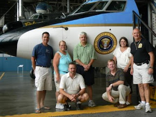
Since this was our last night together, we decided to order pizza and stay in the patio area of the Hope Hotel. As usual, Orlen missed the first group pictures (he was calling to wish his dad a happy 91st birthday).

We finally got all the guys together for a 2192 Comm. picture.


A great time was had by all thanks to Ernie who contacted everyone and made the reunion possible. Great job, Ernie!

Saturday, August 18, 2007

Wifi connection again! August 15-17

August 15th was another geocaching day. We found 7 caches in Prestonsburg, KY. As we searched, we explored the small town and the local college campus. It was another hot day, but not as hot as it had been. We took a picnic lunch and ate at a local veterans' park we found near a cache.
August 16th was a travel day. We drove from Jenny Wiley State Resort Park to Wright Patterson AFB, OH. It was also the last day Bob is allowed to choose the route. Please remember that we are traveling in a 33 foot motor home which tows our truck. As we were leaving the park, Bob said let's take this road--it looks like a good shortcut on the map. As we turned onto the road, I said it didn't look like a road for us, there was no center line. His reply was that it had faded. Yeah, right. As we drove the first 100 yards, I said we need to turn around, this road is not for us. Bob's reply was that it would be okay. A little further on, he began to agree. We were in the knob and hollow area of eastern Kentucky--the roads had many curves and they were steep. Now remember this was just a small rural road. Our rig 8 feet wide--the road was maybe 12 feet when we started. And then.....
the road narrowed to about 10 or 11 feet. At that point Bob wanted to turn around, but there was no place wide enough for us to do that. We had to continue for the remaining 12 miles of this road. Needless to say, when Bob said get the camera so we can have a picture, I couldn't loosen my hands from the armrests, let alone take my seatbelt off to get the camera! That was the most harrowing ride of my life.
After our 45 minute shortcut, we continued on our way on a much better road. Things went much better until we got to the Ohio river. We made a wrong turn and were just going to go around the block to get back on track. Well, as we were driving along, there appeared a sign that said 12 foot clearance ahead. Our rig is 11'6" tall. We slowed down to look, at the train overpass and decided that it didn't look tall enough. Bob turned into a nearby driveway. A gentleman from the car wash across the street came over to see if we needed help. He stopped traffic after we unhooked the truck. Bob backed the rig across the street into the area of the carwash. We rehooked the truck, said thank you to our helper and backtracked to where we made our wrong turn.We hoped that would be our last misadventure of the day.
Our drive through Ohio to Wright Patterson AFB proved uneventful. We checked in and enjoyed the rest of the evening. What a day!
August 17
This was the day we were to meet our friends from 30 years ago for our first military reunion. We talked to Ernie (who planned the reunion) and found out everyone would be arriving at the Hope Convention Center and Hotel around noon. Bob Hope was a familiar face to the military for many years and the center is named for him. Bob and I arrived at the restaurant about noon. We were worried we wouldn't recognize anyone since it had been 30 years since we had seen any of the attendees. It wasn't too long before a group of four 'old men' came wandering into the restaurant like they were looking for someone. Low and behold it was part of our group (Brad, Hammy, Ernie and Fred)! It was a good thing Bob and I hadn't aged so they were able to recognize us. We started where we left off as the pictures show. Ed, Doreen, and Orlen were the last to arrive to complete our group. Yes, Doreen and I were the only 2 wives brave enough to attend.

Ernie planned a great evening for us. After an extended road trip, we arrived at Valley Vineyard for dinner. This is the second largest vineyard in Ohio. The restaurant allows you to grill salmon or steak on their outdoor charcoal grills. Everyone enjoyed the comraderie and good meal.


On returning to the Hope Center we went to a confernence room to view movies and pictures of our time together at Loring AFB, Maine. The memories and stories flowed as freely as the beer.
We arranged to meet for breakfast the next morning.